 |
SEALEVEL STATION CATALOG (SSC) |
|
|
|
|
|
| Station catalog metadata [edit] | [station overview] |
|---|
| SSC ID | SSC-masi | | Station Name | Masirah | | Country | Oman | | Latitude | 20.6833 | | Longitude | 58.8667 | | DateLastModified | 2015-10-22 19:02:29 |
| Linked codes |
|---|
| Codes | Location | Latitude | Longitude | Sensors | IOC: masi | Masirah | 20.6833 | 58.8667 | rad, prs, enc |
IOC: masi2 | Masirah | 20.6833 | 58.8667 | rad, prs, enc |
UHSLC: 113 | Masirah | 20.6867 | 58.8717 | N/A |
PTWC: masi | Masirah_OM | 20.6833 | 58.8667 | rad |
PSMSL: 1887 | MASIRAH | 20.683333 | 58.866667 | N/A |
| Distributed metadata source: IOC Sea Level Station Monitoring Facility masi |
|---|
| Status | Down |
| Local Contact | Civil Aviation Authority ( Oman ) |
| Other Contact | Directorate General Meteorology and Air Navigation ( Oman ) |
| Connection | GTS message |
| Country | Oman |
| Sensor 1 | |
| Type of sensor | rad |
| Sampling rate (min) | 1 |
| Sensor 2 | |
| Type of sensor | prs |
| Sampling rate (min) | 1 |
| Sensor 3 | |
| Type of sensor | enc |
| Sampling rate (min) | 1 |
| Distributed metadata source: IOC Sea Level Station Monitoring Facility masi2 |
|---|
| GTS station code | 16288114 |
| GTS message type | SXOM32 |
| Status | Operational |
| Local Contact | Directorate General Meteorology and Air Navigation ( Oman ) |
| Connection | GTS message |
| Country | Oman |
| Sensor 1 | |
| Type of sensor | rad |
| Sampling rate (min) | 1 |
| Sensor 2 | |
| Type of sensor | prs |
| Sampling rate (min) | 1 |
| Sensor 3 | |
| Type of sensor | enc |
| Sampling rate (min) | 1 |
| Distributed metadata source: PTWC COMP META file |
| DCP ID | 16288114 |
| WMO | SXOM32 |
| Samp Rate | 1 |
| Num# Samp | 15 |
| Unit | C |
| Scale | 1.0000 |
| Xmt Int. | 006 |
| Fst Min. | 0001 |
| HAR | 1 |
| Owner | DGMAN |
| Distributed metadata source: UHSLC |
| UHSLC id | 113 |
| SSC id | masi |
| UHSLC geojson | https://uhslc.soest.hawaii.edu/data/meta.geojson |
| Research quality data version a | 1996-12-07 - 2018-12-31 |
| RQ basin | indian |
| Fast delivery | 1996-12-07 - 2019-12-13 |
| Distributed metadata source: PSMSL |
| Name | MASIRAH |
| UHSLC ID | 113 |
| Is RLR | Y |
| Has RLR Diagram | Y link |
| QC Flag | N |
| Old ID | 487/012 |
| Last Updated | 2020-01-29 |
| Supplier | UNIVERSITY OF HAWAII SEA LEVEL CENTER |
| Address | University of Hawaii Sea Level Center, Department of Oceanography Division of Natural Sciences, 1000 Pope Road, Honolulu, Hawaii 96822, UNITED STATES |
| Metric Start | 1996 |
| Metric End | 2018 |
| Metric Completeness | 82.6 |
| RLR Start | 1996 |
| RLR End | 2018 |
| RLR Completeness | 82.6 |
| Download metric sea level data. | Use only with extreme caution. |
IOC Sea Level Station Monitoring Facility - realtime graph for 'masi'  IOC Sea Level Station Monitoring Facility - realtime graph for 'masi2' 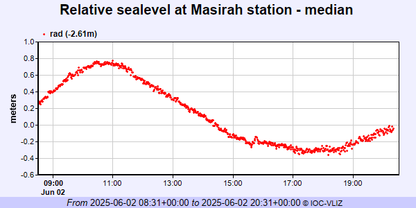 PSMSL Annual Mean Sea Level for '1887' 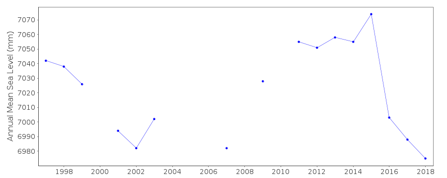 PSMSL Monthly Mean Sea Level for '1887' 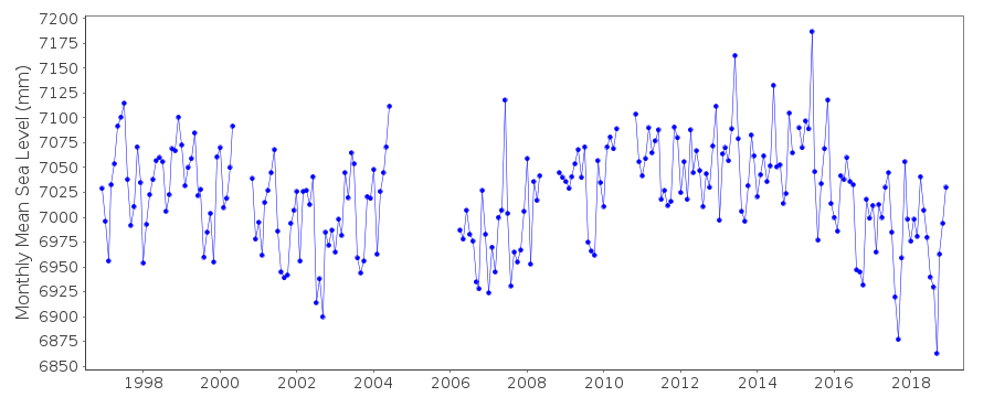
|
|
|