 |
SEALEVEL STATION CATALOG (SSC) |
|
|
|
|
|
| Station catalog metadata [edit] | [station overview] |
|---|
| SSC ID | SSC-mani | | Station Name | Manila | | Country | Philippines | | Latitude | 14.5833 | | Longitude | 120.9667 | | DateLastModified | 2015-10-22 19:02:29 |
| Distributed metadata source: IOC Sea Level Station Monitoring Facility mani |
|---|
| GTS station code | 301434060194630 |
| GTS message type | SZXX01 |
| Status | Operational |
| Local Contact | National Mapping and Resource Information Authority ( Philippines ) |
| Other Contact | University of Hawaii Sea Level Center ( USA ) |
| Connection | GTS message |
| Country | Philippines |
| Sensor 1 | |
| Type of sensor | rad |
| Sampling rate (min) | 1 |
| Sensor 2 | |
| Type of sensor | prs |
| Sampling rate (min) | 1 |
| Sensor 3 | |
| Type of sensor | ra2 |
| Sampling rate (min) | 1 |
| Sensor 4 | |
| Type of sensor | bat |
| Sampling rate (min) | 5 |
| Sensor 5 | |
| Type of sensor | sw1 |
| Sampling rate (min) | 60 |
| Sensor 6 | |
| Type of sensor | sw2 |
| Sampling rate (min) | 60 |
| Distributed metadata source: GLOSS Station Handbook |
|---|
| Time Zone | 120E, GMT + 8hrs | | Ocean | Pacific | | Operational | Yes | | Responsible country | Philippines | | Additional parameters | Sea surface temperature, surface salinity at 15degC | | Tide gauge benchmarks | BM-4B - Tramus, Manila, brass rod embedded on concrete base, 1.0m above street level. At back of former Central Bank building, at concrete base of Meraclo power outlet, almost opposite the bank's door. | | Benchmark relationships | BM-4B established 1985, elevation 5.3065m above OTS.
Previous benchmark BM-4B, defaced, elevation 5.3168m above OTS (difference -0.0103m).
| | Other relevant information | Station El Codo was operational from Jan 1976 to Sep 1980 | | Other relevant codes | UHSLC 370 | | Nearest Met. station | 5km from tide gauge |
| Distributed metadata source: PTWC COMP META file |
| DCP ID | 301434060194630 |
| WMO | SZXX01 |
| Samp Rate | 1 |
| Num# Samp | 5 |
| Unit | M |
| Scale | 1.0000 |
| Xmt Int. | 005 |
| Fst Min. | 0001 |
| HAR | 1 |
| Owner | UHSLC |
| Distributed metadata source: UHSLC |
| UHSLC id | 370 |
| SSC id | mani |
| GLOSS id | 73 |
| UHSLC geojson | https://uhslc.soest.hawaii.edu/data/meta.geojson |
| Research quality data version a | 1984-01-01 - 2024-12-31 |
| RQ basin | pacific |
| Fast delivery | 1984-01-01 - 2026-05-31 |
| Distributed metadata source: PSMSL |
| Name | MANILA, S. HARBOR |
| GLOSS id | 73 |
| UHSLC ID | 370 |
| SONEL id | 3238 |
| Is RLR | Y |
| Has RLR Diagram | Y link |
| QC Flag | Y |
| Old ID | 660/011 |
| Last Updated | 2025-06-18 |
| Supplier | NATIONAL MAPPING AND RESOURCE INFORMATION AUTHORITY |
| Address | National Mapping and Resource Information Authority, Hydrography Department, 421 Barraca St,, San Nicolas 1010, Manila , PHILIPPINES |
| Metric Start | 1901 |
| Metric End | 2024 |
| Metric Completeness | 84.9 |
| RLR Start | 1901 |
| RLR End | 2024 |
| RLR Completeness | 84.9 |
| Download metric sea level data. | Use only with extreme caution. |
IOC Sea Level Station Monitoring Facility - realtime graph for 'mani' 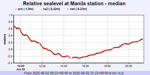 PSMSL Annual Mean Sea Level for '145' 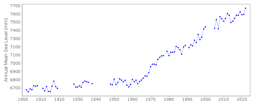 PSMSL Monthly Mean Sea Level for '145' 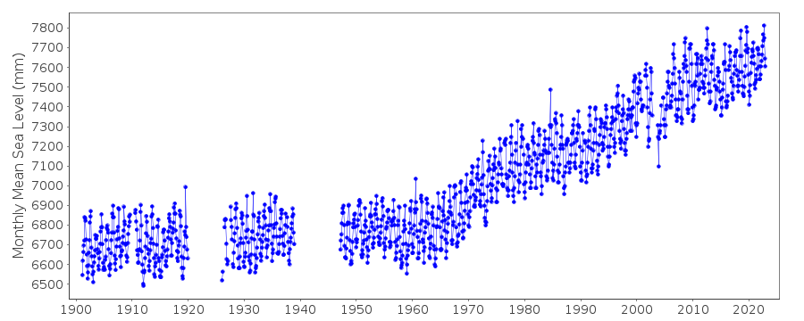
|
|
|