 |
SEALEVEL STATION CATALOG (SSC) |
|
|
|
|
|
| Station catalog metadata [edit] | [station overview] |
|---|
| SSC ID | SSC-madry | | Station Name | Puerto Madryn | | Country | Argentina | | Latitude | -42.76265 | | Longitude | -65.03068611 | | DateLastModified | 2015-10-22 19:02:29 |
| Linked codes |
|---|
| Codes | Location | Latitude | Longitude | Sensors | IOC: madry | Puerto Madryn | -42.76265 | -65.03068611 | prs, rad, ra2, bat, sw1, sw2, ra3 |
GLOSS: 191 | Puerto Madryn | -42.76666 | -65.03333 | Float |
UHSLC: 731 | Puerto Madryn | -42.76268 | -65.03084 | N/A |
PTWC: madr | Madryn_AR | -42.7627 | -65.0308 | ra2, ra3 |
PSMSL: 2305 | PUERTO MADRYN II | -42.766667 | -65.033333 | N/A |
PSMSL: 501 | PUERTO MADRYN | -42.766667 | -65.033333 | N/A |
SONEL_GPS: 924 | N/A | | | N/A |
SONEL_TG: 2339 | PUERTO MADRYN | -42.76224600 | -65.02756600 | N/A |
| Distributed metadata source: IOC Sea Level Station Monitoring Facility madry |
|---|
| GTS station code | 301434062419770 |
| GTS message type | SZXX01 |
| Status | Operational |
| Local Contact | Armada Argentina Servicio de Hidrografía Naval ( Argentina ) |
| Other Contact | University of Hawaii Sea Level Center ( USA ) |
| Connection | GTS message |
| Country | Argentina |
| Sensor 1 | |
| Type of sensor | prs |
| Sensor 2 | |
| Type of sensor | sw1 |
| Sensor 3 | |
| Type of sensor | sw2 |
| Sensor 4 | |
| Type of sensor | ra3 |
| Sampling rate (min) | 1 |
| Sensor 5 | |
| Type of sensor | rad |
| Sampling rate (min) | 3 |
| Sensor 6 | |
| Type of sensor | ra2 |
| Sampling rate (min) | 1 |
| Sensor 7 | |
| Type of sensor | bat |
| Sampling rate (min) | 5 |
| Distributed metadata source: GLOSS Station Handbook |
|---|
| Time Zone | 045W, GMT - 3hrs | | Ocean | Atlantic | | Operational | Yes | | Responsible country | Argentina | | Data acquisition rate | Hourly recording | | Additional parameters | None | | Tide gauge benchmarks | Benchmark bolt inside tide gauge hut adjacent to stilling well. | | Benchmark relationships | Tide gauge zero (TGZ) = local chart datum
TGZ = 2.83m below 'O' IGM
TGZ = 8.22m below TGBM (from 1944 onwards)
| | Auxiliary benchmarks | AUX 1: punto fijo ubicado en la parte superior del tubo maregrafico adyacente.
AUX 2: punto fijo Nodal A (IGM), ubicado en los jardines de la Estacion Terminal de Omnibus de Pto. Madryn.
|
| Distributed metadata source: PTWC COMP META file |
| DCP ID | 301434062419770 |
| WMO | SZXX01 |
| Samp Rate | 1 |
| Num# Samp | 5 |
| Unit | M |
| Scale | 1.0000 |
| Xmt Int. | 005 |
| Fst Min. | 0001 |
| HAR | 1 |
| Owner | SHN |
| Distributed metadata source: UHSLC |
| UHSLC id | 731 |
| SSC id | madry |
| GLOSS id | 191 |
| UHSLC geojson | https://uhslc.soest.hawaii.edu/data/meta.geojson |
| Research quality data version a | 2010-03-14 - 2024-12-31 |
| RQ basin | atlantic |
| Fast delivery | 2010-03-14 - 2026-04-30 |
| Distributed metadata source: PSMSL |
| Name | PUERTO MADRYN II |
| GLOSS id | 191 |
| UHSLC ID | 731 |
| Is RLR | N |
| Has RLR Diagram | N link |
| QC Flag | N |
| Old ID | 860/033 |
| Last Updated | 2024-01-03 |
| Supplier | SERVICIO DE HIDROGRAFIA NAVAL, ARGENTINA |
| Address | Servicio de Hidrografia Naval, Departmento Oceanografia, Av. Montes de Oca 2124, 1271 Buenos Aires, ARGENTINA |
| Metric Start | 2010 |
| Metric End | 2022 |
| Metric Completeness | 96.8 |
| Download metric sea level data. | Use only with extreme caution. |
| Name | PUERTO MADRYN |
| GLOSS id | 191 |
| UHSLC ID | 731 |
| Is RLR | Y |
| Has RLR Diagram | Y link |
| QC Flag | N |
| Old ID | 860/031 |
| Last Updated | 2023-02-01 |
| Supplier | SERVICIO DE HIDROGRAFIA NAVAL, ARGENTINA |
| Address | Servicio de Hidrografia Naval, Departmento Oceanografia, Av. Montes de Oca 2124, 1271 Buenos Aires, ARGENTINA |
| Metric Start | 1944 |
| Metric End | 2021 |
| Metric Completeness | 68.8 |
| RLR Start | 1944 |
| RLR End | 2021 |
| RLR Completeness | 68.8 |
| Download metric sea level data. | Use only with extreme caution. |
IOC Sea Level Station Monitoring Facility - realtime graph for 'madry' 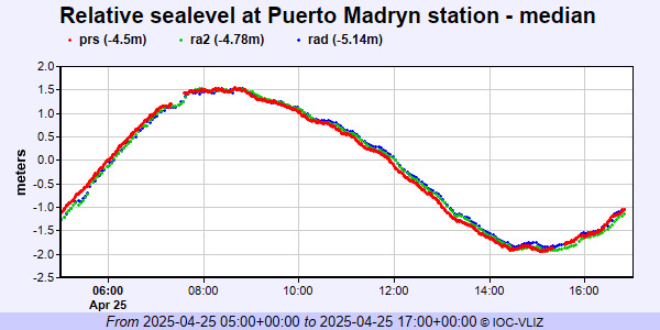 PSMSL Annual Mean Sea Level for '2305'  PSMSL Annual Mean Sea Level for '501' 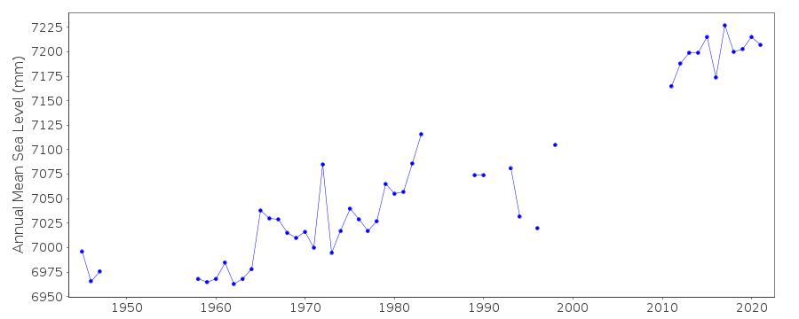 PSMSL Monthly Mean Sea Level for '501' 
|
|
|