 |
SEALEVEL STATION CATALOG (SSC) |
|
|
|
|
|
| Station catalog metadata [edit] | [station overview] |
|---|
| SSC ID | SSC-lorn | | Station Name | Lorne | | Country | Australia | | Latitude | -38.547194 | | Longitude | 143.988833 | | DateLastModified | 2015-10-22 19:02:29 |
| Linked codes |
|---|
| Codes | Location | Latitude | Longitude | Sensors | PSMSL: 1836 | LORNE | -38.547194 | 143.988833 | N/A |
| Distributed metadata source: PSMSL |
| Name | LORNE |
| Is RLR | Y |
| Has RLR Diagram | Y link |
| QC Flag | N |
| Old ID | 680/226 |
| Last Updated | 2025-03-20 |
| Supplier | NATIONAL TIDAL CENTRE |
| Address | National Tidal Centre, Bureau of Meteorology, PO Box 421, Kent Town 5071, South Australia, AUSTRALIA |
| Metric Start | 1993 |
| Metric End | 2025 |
| Metric Completeness | 96.5 |
| RLR Start | 1993 |
| RLR End | 2025 |
| RLR Completeness | 96.5 |
| Download metric sea level data. | Use only with extreme caution. |
PSMSL Annual Mean Sea Level for '1836' 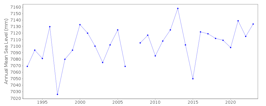 PSMSL Monthly Mean Sea Level for '1836' 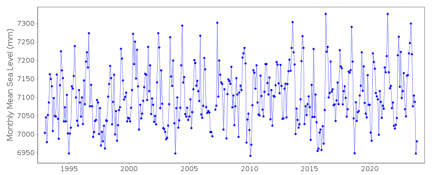
|
|
|