 |
SEALEVEL STATION CATALOG (SSC) |
|
|
|
|
|
| Station catalog metadata [edit] | [station overview] |
|---|
| SSC ID | SSC-londi | | Station Name | London Bridge | | Country | United Kingdom | | Latitude | 51.5 | | Longitude | 0.083333 | | DateLastModified | 2015-10-22 19:02:29 |
| Linked codes |
|---|
| Codes | Location | Latitude | Longitude | Sensors | PSMSL: 1947 | LONDON BRIDGE | 51.5 | 0.083333 | N/A |
PSMSL: 336 | TOWER PIER | 51.5 | 0.083333 | N/A |
| Distributed metadata source: PSMSL |
| Name | LONDON BRIDGE |
| Is RLR | N |
| Has RLR Diagram | N link |
| QC Flag | N |
| Old ID | 170/091 |
| Last Updated | null |
| Supplier | N.O.C. |
| Address | British Oceanographic Data Centre, National Oceanography Centre, Joseph Proudman Building, 6 Brownlow Street, Liverpool, L3 5DA, UNITED KINGDOM |
| Metric Start | 1925 |
| Metric End | 1925 |
| Metric Completeness | 100.0 |
| Download metric sea level data. | Use only with extreme caution. |
| Name | TOWER PIER |
| Is RLR | Y |
| Has RLR Diagram | Y link |
| QC Flag | N |
| Old ID | 170/092 |
| Last Updated | 2018-01-17 |
| Supplier | PORT OF LONDON AUTHORITY |
| Address | Port of London Authority, London River House, Royal Pier Road, Gravesend, Kent DA12 2BG, UNITED KINGDOM |
| Metric Start | 1929 |
| Metric End | 2013 |
| Metric Completeness | 65.4 |
| RLR Start | 1929 |
| RLR End | 2013 |
| RLR Completeness | 65.4 |
| Download metric sea level data. | Use only with extreme caution. |
PSMSL Annual Mean Sea Level for '1947'  PSMSL Annual Mean Sea Level for '336' 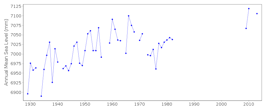 PSMSL Monthly Mean Sea Level for '336' 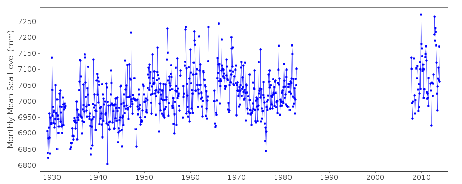
|
|
|