 |
SEALEVEL STATION CATALOG (SSC) |
|
|
|
|
|
| Station catalog metadata [edit] | [station overview] |
|---|
| SSC ID | SSC-lmpd | | Station Name | Lampedusa | | Country | Italy | | Latitude | 35.4998 | | Longitude | 12.6044 | | DateLastModified | 2015-10-22 19:28:52 |
| Linked codes |
|---|
| Codes | Location | Latitude | Longitude | Sensors | IOC: LA23 | Lampedusa | 35.4998 | 12.6044 | rad |
PTWC: lamp | Lampedusa_IT | 35.4998 | 12.6044 | rad |
PSMSL: 2079 | LAMPEDUSA | 35.499828 | 12.604439 | N/A |
SONEL_GPS: 722 | LAMPEDUSA | 35.49977385 | 12.60565606 | N/A |
SONEL_TG: 2226 | LAMPEDUSA | 35.49959100 | 12.60424000 | N/A |
| Distributed metadata source: IOC Sea Level Station Monitoring Facility LA23 |
|---|
| Status | Operational |
| Local Contact | Istituto Superiore per la Protezione e la Ricerca Ambientale ( Italy ) |
| Connection | WEB service |
| Country | Italy |
| Sensor 1 | |
| Type of sensor | rad |
| Sampling rate (min) | 1 |
| Distributed metadata source: PTWC COMP META file |
| DCP ID | 1234AACC |
| WMO | FTPI00 |
| Samp Rate | 1 |
| Num# Samp | 10 |
| Unit | m |
| Scale | 1.0000 |
| Xmt Int. | 010 |
| Fst Min. | 0000 |
| HAR | 1 |
| Owner | ISPRA |
| Distributed metadata source: PSMSL |
| Name | LAMPEDUSA |
| SONEL id | 722 |
| Is RLR | Y |
| Has RLR Diagram | Y link |
| QC Flag | N |
| Old ID | 260/025 |
| Last Updated | 2026-05-08 |
| Supplier | ISPRA |
| Address | Institute for Environmental Protection and Research, Via Vitaliano , Brancati 48, 00144 Roma, ITALY |
| Metric Start | 2001 |
| Metric End | 2025 |
| Metric Completeness | 98.0 |
| RLR Start | 2001 |
| RLR End | 2025 |
| RLR Completeness | 98.0 |
| Download metric sea level data. | Use only with extreme caution. |
IOC Sea Level Station Monitoring Facility - realtime graph for 'LA23' 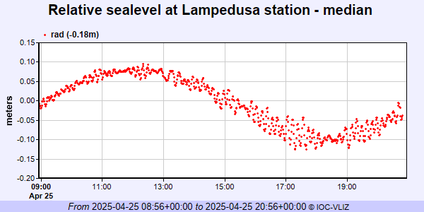 PSMSL Annual Mean Sea Level for '2079' 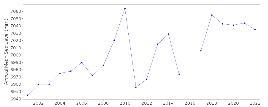 PSMSL Monthly Mean Sea Level for '2079' 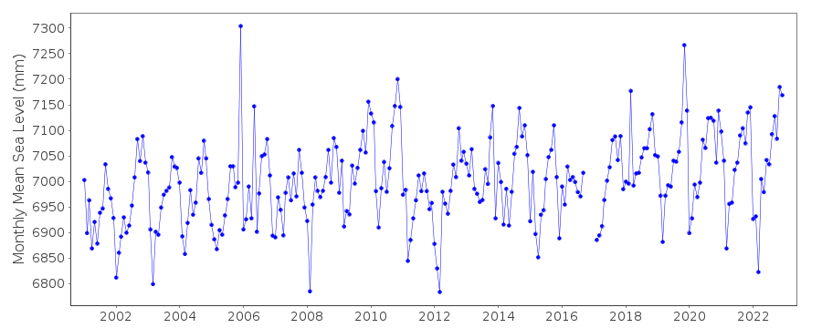
|
|
|