 |
SEALEVEL STATION CATALOG (SSC) |
|
|
|
|
|
| Station catalog metadata [edit] | [station overview] |
|---|
| SSC ID | SSC-levk | | Station Name | Levkas | | Country | Greece | | Latitude | 38.834544 | | Longitude | 20.712108 | | DateLastModified | 2015-10-22 19:02:29 |
| Distributed metadata source: PSMSL |
| Name | LEVKAS |
| SONEL id | 2584 |
| Is RLR | Y |
| Has RLR Diagram | Y link |
| QC Flag | N |
| Old ID | 290/004 |
| Last Updated | 2026-03-13 |
| Supplier | HELLENIC NAVY HYDROGRAPHIC SERVICE |
| Address | Hellenic Navy Hydrographic Service, Geographic Policy and International Relations Office, TGN 1040, Athens, GREECE |
| Metric Start | 1969 |
| Metric End | 2025 |
| Metric Completeness | 86.0 |
| RLR Start | 1969 |
| RLR End | 2025 |
| RLR Completeness | 86.0 |
| Download metric sea level data. | Use only with extreme caution. |
PSMSL Annual Mean Sea Level for '1239' 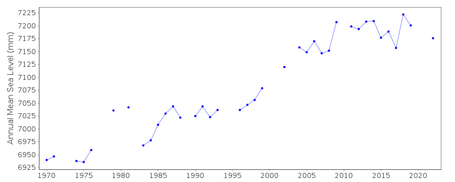 PSMSL Monthly Mean Sea Level for '1239' 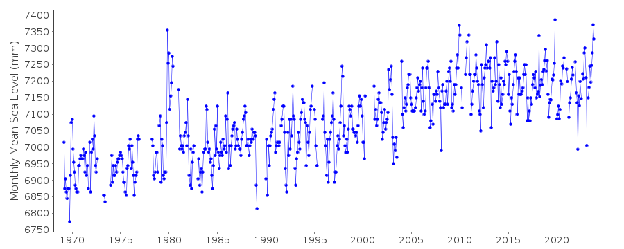
|
|
|