 |
SEALEVEL STATION CATALOG (SSC) |
|
|
|
|
|
| Station catalog metadata [edit] | [station overview] |
|---|
| SSC ID | SSC-lega | | Station Name | Legaspi, Albay | | Country | Philippines | | Latitude | 13.146214 | | Longitude | 123.758117 | | DateLastModified | 2015-10-22 19:02:29 |
| Linked codes |
|---|
| Codes | Location | Latitude | Longitude | Sensors | IOC: lega | Legaspi | 13.146214 | 123.758117 | rad, prs, bat, ra2, sw1, sw2 |
GLOSS: 72 | Legaspi, Albay | 13.15 | 123.75 | Float |
UHSLC: 371 | Legaspi | 13.14475 | 123.75658 | N/A |
PTWC: lega | Legaspi_PH | 13.1447 | 123.7566 | prs, ra2, rad |
PSMSL: 522 | LEGASPI, ALBAY | 13.15 | 123.75 | N/A |
SONEL_GPS: 3503 | LEGASPI | 13.16121884 | 123.72972630 | N/A |
SONEL_TG: 2825 | LEGASPI | 13.14621400 | 123.75811700 | N/A |
| Distributed metadata source: IOC Sea Level Station Monitoring Facility lega |
|---|
| GTS station code | 301434061601080 |
| GTS message type | SZXX01 |
| Status | Operational |
| Local Contact | National Mapping and Resource Information Authority ( Philippines ) |
| Other Contact | University of Hawaii Sea Level Center ( USA ) |
| Connection | GTS message |
| Country | Philippines |
| Sensor 1 | |
| Type of sensor | rad |
| Sampling rate (min) | 1 |
| Sensor 2 | |
| Type of sensor | prs |
| Sampling rate (min) | 1 |
| Sensor 3 | |
| Type of sensor | bat |
| Sampling rate (min) | 5 |
| Sensor 4 | |
| Type of sensor | ra2 |
| Sampling rate (min) | 1 |
| Sensor 5 | |
| Type of sensor | sw1 |
| Sampling rate (min) | 60 |
| Sensor 6 | |
| Type of sensor | sw2 |
| Sampling rate (min) | 60 |
| Distributed metadata source: GLOSS Station Handbook |
|---|
| Time Zone | 120E, GMT + 8hrs | | Ocean | Pacific | | Operational | Yes | | Responsible country | Philippines | | Additional parameters | Sea surface temperature, surface salinity at 15degC | | Tide gauge benchmarks | BM-2 - Port of Legaspi, Albay. Cross cut on brass rod set in drilled hole on concrete base of monument located at the northern side of the wharf, 0.42m from the corner of the base; no inscription around mark. | | Benchmark relationships | BM-2 was established in 1947 | | Auxiliary benchmarks | BMX, BP1, Z, Z1, Z2, 4A, 5B, AL-ZA (first order benchmark) | | Other relevant codes | UHSLC 371 | | Nearest Met. station | 5km from tide gauge |
| Distributed metadata source: PTWC COMP META file |
| DCP ID | 301434061601080 |
| WMO | SZXX01 |
| Samp Rate | 1 |
| Num# Samp | 5 |
| Unit | M |
| Scale | 1.0000 |
| Xmt Int. | 005 |
| Fst Min. | 0001 |
| HAR | 1 |
| Owner | UHSLC |
| Distributed metadata source: UHSLC |
| UHSLC id | 371 |
| SSC id | lega |
| GLOSS id | 72 |
| UHSLC geojson | https://uhslc.soest.hawaii.edu/data/meta.geojson |
| Research quality data version a | 1984-01-01 - 2017-09-04 |
| RQ basin | pacific |
| Fast delivery | 1984-01-01 - 2026-05-31 |
| Distributed metadata source: PSMSL |
| Name | LEGASPI, ALBAY |
| GLOSS id | 72 |
| UHSLC ID | 371 |
| Is RLR | Y |
| Has RLR Diagram | N link |
| QC Flag | N |
| Old ID | 660/021 |
| Last Updated | 2025-06-18 |
| Supplier | NATIONAL MAPPING AND RESOURCE INFORMATION AUTHORITY |
| Address | National Mapping and Resource Information Authority, Hydrography Department, 421 Barraca St,, San Nicolas 1010, Manila , PHILIPPINES |
| Metric Start | 1947 |
| Metric End | 2024 |
| Metric Completeness | 94.0 |
| RLR Start | 1947 |
| RLR End | 2024 |
| RLR Completeness | 94.0 |
| Download metric sea level data. | Use only with extreme caution. |
IOC Sea Level Station Monitoring Facility - realtime graph for 'lega' 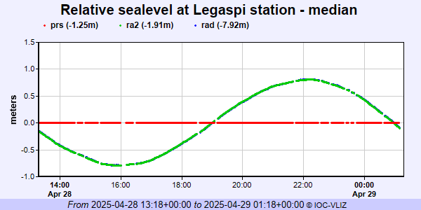 PSMSL Annual Mean Sea Level for '522' 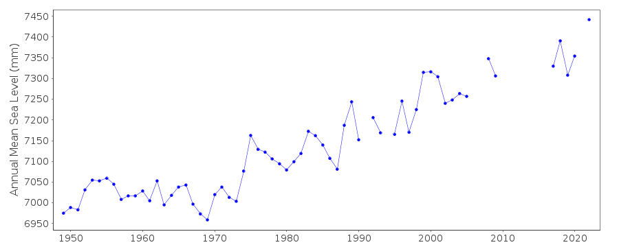 PSMSL Monthly Mean Sea Level for '522' 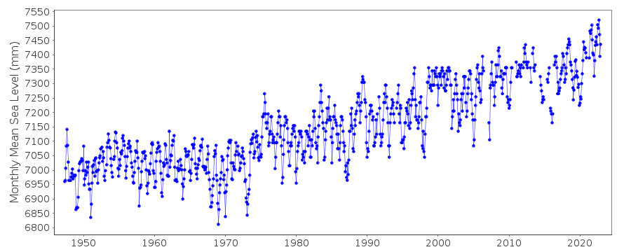
|
|
|