 |
SEALEVEL STATION CATALOG (SSC) |
|
|
|
|
|
| Station catalog metadata [edit] | [station overview] |
|---|
| SSC ID | SSC-laoh | | Station Name | Laohutan | | Country | China | | Latitude | 38.86666 | | Longitude | 121.68333 | | DateLastModified | 2025-05-08 22:03:34 |
| Distributed metadata source: GLOSS Station Handbook |
|---|
| Time Zone | 120E, GMT + 8hrs | | Ocean | Pacific | | Operational | Yes | | Data acquisition rate | Recording at hourly intervals | | Additional parameters | Surface T and S, wave and meteorological parameters | | Tide gauge benchmarks | TGBM (WCSBM) is in the WC street and 3180m from the gauge well | | Benchmark relationships | Tide Gauge Zero (TGZ) = 5.565m below WCSBM.
TGZ = 2.206m below MSL of Yellow Sea (1956-old)
TGZ = 2.246m below MSL of Yellow Sea (1985-new)
TGZ = 2.233m below MSL of Dalian (outside Shanghaiguan)
| | Other relevant information | Dalian tide gauge benchmarks: TGBM (BM1) is 9.07m from south side of the north pier and 23.73m from the NE corner of the storehouse.
TGZ = 6.000m below BM1
TGZ = 0.797m below BM9 (located on the window sill on the first floor of Dalian Port Office building)
TGZ = 2.1279m below MSL of Yellow Sea (1956-old)
TGZ = 2.166m below MSL of Yellow Sea (1985-new)
| | Other relevant codes | Laohutan - UHSLC 631, Dalian - UHSLC 630 | | Nearest Met. station | Dalian MS |
| Distributed metadata source: UHSLC |
| UHSLC id | 630 |
| SSC id | dali |
| GLOSS id | 79 |
| UHSLC geojson | https://uhslc.soest.hawaii.edu/data/meta.geojson |
| Research quality data version a | 1975-01-01 - 1990-12-31 |
| RQ basin | pacific |
| UHSLC id | 631 |
| SSC id | laoh |
| GLOSS id | 79 |
| UHSLC geojson | https://uhslc.soest.hawaii.edu/data/meta.geojson |
| Research quality data version a | 1991-01-01 - 1997-12-31 |
| RQ basin | pacific |
| Distributed metadata source: PSMSL |
| Name | LAOHUTAN |
| GLOSS id | 79 |
| UHSLC ID | 630 |
| Is RLR | Y |
| Has RLR Diagram | Y link |
| QC Flag | N |
| Old ID | 610/045 |
| Last Updated | 1998-04-20 |
| Supplier | NATIONAL MARINE DATA AND INFORMATION SERVICE (NMDIS) |
| Address | National Marine Data and Information Service (NMDIS), No. 93 Liuwei Road, Tianjin 300171, CHINA |
| Metric Start | 1980 |
| Metric End | 1997 |
| Metric Completeness | 100.0 |
| RLR Start | 1980 |
| RLR End | 1997 |
| RLR Completeness | 100.0 |
| Download metric sea level data. | Use only with extreme caution. |
| Name | DALIAN |
| GLOSS id | 79 |
| UHSLC ID | 630 |
| Is RLR | Y |
| Has RLR Diagram | Y link |
| QC Flag | N |
| Old ID | 610/044 |
| Last Updated | 2025-03-27 |
| Supplier | NATIONAL MARINE DATA AND INFORMATION SERVICE (NMDIS) |
| Address | National Marine Data and Information Service (NMDIS), No. 93 Liuwei Road, Tianjin 300171, CHINA |
| Metric Start | 1954 |
| Metric End | 2024 |
| Metric Completeness | 83.2 |
| RLR Start | 1954 |
| RLR End | 2024 |
| RLR Completeness | 81.8 |
| Download metric sea level data. | Use only with extreme caution. |
PSMSL Annual Mean Sea Level for '1513' 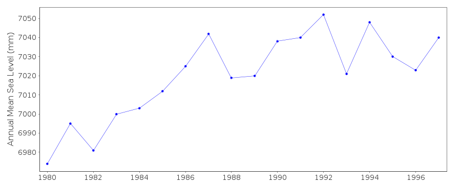 PSMSL Annual Mean Sea Level for '723' 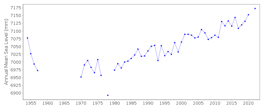 PSMSL Monthly Mean Sea Level for '723' 
|
|
|