 |
SEALEVEL STATION CATALOG (SSC) |
|
|
|
|
|
| Station catalog metadata [edit] | [station overview] |
|---|
| SSC ID | SSC-lajo | | Station Name | La Jolla | | Country | United States | | Latitude | 32.867 | | Longitude | -117.258 | | DateLastModified | 2015-10-22 19:02:29 |
| Linked codes |
|---|
| Codes | Location | Latitude | Longitude | Sensors | IOC: lajo | La_Jolla_CA | 32.867 | -117.258 | bwl |
IOC: lajo2 | La_Jolla_CA | 32.867 | -117.258 | pwl |
GLOSS: 159 | La Jolla (Scripps Pier) CA | 32.86666 | -117.26666 | Float, Bubbler, Acoustic |
UHSLC: 554 | La Jolla | 32.8667 | -117.2567 | N/A |
PTWC: lajo | La_Jolla_CA | 32.8669 | -117.2570 | pwc, pwl, bwl |
PSMSL: 256 | LA JOLLA (SCRIPPS PIER) | 32.866667 | -117.256667 | N/A |
SONEL_GPS: 3465 | LA JOLLA | 32.84073511 | -117.24969096 | N/A |
SONEL_GPS: 843 | LA JOLLA | 32.86470250 | -117.25040699 | N/A |
SONEL_TG: 2364 | LA JOLLA | 32.86693200 | -117.25708000 | N/A |
| Distributed metadata source: IOC Sea Level Station Monitoring Facility lajo |
|---|
| GTS station code | 3361F4F4 |
| GTS message type | SXXX03 |
| Status | Operational |
| Local Contact | National Ocean Service-NOAA ( USA ) |
| Connection | WEB service |
| Country | USA |
| Sensor 1 | |
| Type of sensor | bwl |
| Sampling rate (min) | 6 |
| Distributed metadata source: IOC Sea Level Station Monitoring Facility lajo2 |
|---|
| GTS station code | 3361F4F4 |
| GTS message type | SXXX03 |
| Status | Operational |
| Local Contact | National Ocean Service-NOAA ( USA ) |
| Connection | GTS message |
| Country | USA |
| Sensor 1 | |
| Type of sensor | pwl |
| Sampling rate (min) | 1 |
| Distributed metadata source: GLOSS Station Handbook |
|---|
| Time Zone | 120W, GMT - 8hrs | | Ocean | Pacific | | Operational | Yes | | Data acquisition rate | 6 minute intervals | | Tide gauge benchmarks | US C&GS tidal benchmark survey disk stamped '7 1958' set in a concrete retaining wall near the south west corner of the Benthic Laboratory Control Center Building at Scripps. | | Benchmark relationships | TGBM = 36.24 feet above mean lower low water (1960-1978 epoch)
TGBM = 33.49 feet above mean sea level (1960-1978 epoch)
TGBM = 31.62 feet above mean high water (1960-1978 epoch)
| | Auxiliary benchmarks | 6 1952 0230 M 1977
BASIC 1929 RESET 1963 0230 N 1977
BASIC 1929 RESET 1963 RESET 1964 0230 P 1977
NO 9 1971 NO 10 1974
0230 L 1977
1993 inspection states 'levels agree with history'
| | Other relevant codes | UHSLC 569 |
| Distributed metadata source: PTWC COMP META file |
| DCP ID | 3361F4F4 |
| WMO | SXXX03 |
| Samp Rate | 6 |
| Num# Samp | 1 |
| Unit | M |
| Scale | 1.3889 |
| Xmt Int. | 006 |
| Fst Min. | 0004 |
| HAR | 1 |
| Owner | NOS |
| Distributed metadata source: UHSLC |
| UHSLC id | 554 |
| SSC id | lajo |
| GLOSS id | 159 |
| UHSLC geojson | https://uhslc.soest.hawaii.edu/data/meta.geojson |
| Research quality data version a | 1924-08-01 - 2024-12-31 |
| RQ basin | pacific |
| Fast delivery | 1924-08-01 - 2026-05-31 |
| Distributed metadata source: PSMSL |
| Name | LA JOLLA (SCRIPPS PIER) |
| GLOSS id | 159 |
| UHSLC ID | 554 |
| SONEL id | 4199 |
| Is RLR | Y |
| Has RLR Diagram | Y link |
| QC Flag | N |
| Old ID | 823/071 |
| Last Updated | 2026-01-27 |
| Supplier | N.O.A.A. / N.O.S. |
| Address | N.O.A.A. / N.O.S., N/oes33, Ssmc4, Room 6531, 1305 East-West Highway, Silver Spring, , MD 20910, UNITED STATES |
| Metric Start | 1924 |
| Metric End | 2025 |
| Metric Completeness | 96.3 |
| RLR Start | 1924 |
| RLR End | 2025 |
| RLR Completeness | 96.3 |
| Download metric sea level data. | Use only with extreme caution. |
IOC Sea Level Station Monitoring Facility - realtime graph for 'lajo' 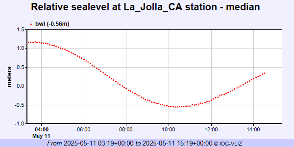 IOC Sea Level Station Monitoring Facility - realtime graph for 'lajo2' 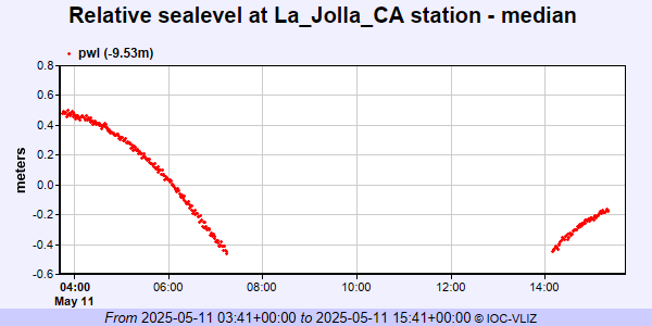 PSMSL Annual Mean Sea Level for '256'  PSMSL Monthly Mean Sea Level for '256' 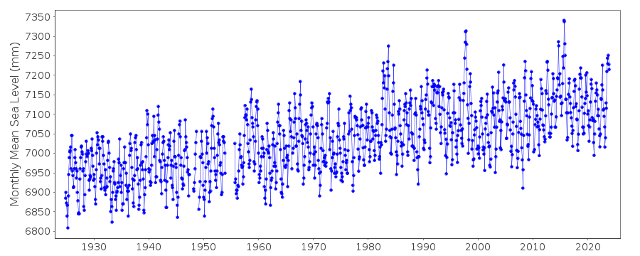
|
|
|