 |
SEALEVEL STATION CATALOG (SSC) |
|
|
|
|
|
| Station catalog metadata [edit] | [station overview] |
|---|
| SSC ID | SSC-kidd | | Station Name | Kidderpore | | Country | India | | Latitude | 22.533333 | | Longitude | 88.333333 | | DateLastModified | 2015-10-22 19:02:29 |
| Linked codes |
|---|
| Codes | Location | Latitude | Longitude | Sensors | PSMSL: 369 | GARDEN REACH | 22.55 | 88.3 | N/A |
PSMSL: 48 | KIDDERPORE | 22.533333 | 88.333333 | N/A |
| Distributed metadata source: PSMSL |
| Name | GARDEN REACH |
| Is RLR | Y |
| Has RLR Diagram | Y link |
| QC Flag | Y |
| Old ID | 500/141 |
| Last Updated | 2026-02-02 |
| Supplier | SURVEY OF INDIA |
| Address | Survey of India, Geodetic and Research Branch, 17 E.C. Road, Dehra Dun , PIN 248 001, INDIA |
| Metric Start | 1932 |
| Metric End | 2024 |
| Metric Completeness | 89.6 |
| RLR Start | 1932 |
| RLR End | 2024 |
| RLR Completeness | 89.6 |
| Download metric sea level data. | Use only with extreme caution. |
| Name | KIDDERPORE |
| Is RLR | Y |
| Has RLR Diagram | Y link |
| QC Flag | Y |
| Old ID | 500/151 |
| Last Updated | null |
| Supplier | SURVEY OF INDIA |
| Address | Survey of India, Geodetic and Research Branch, 17 E.C. Road, Dehra Dun , PIN 248 001, INDIA |
| Metric Start | 1881 |
| Metric End | 1931 |
| Metric Completeness | 45.4 |
| RLR Start | 1881 |
| RLR End | 1931 |
| RLR Completeness | 45.4 |
| Download metric sea level data. | Use only with extreme caution. |
PSMSL Annual Mean Sea Level for '369' 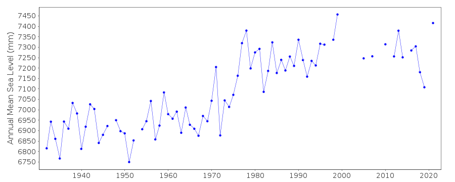 PSMSL Annual Mean Sea Level for '48' 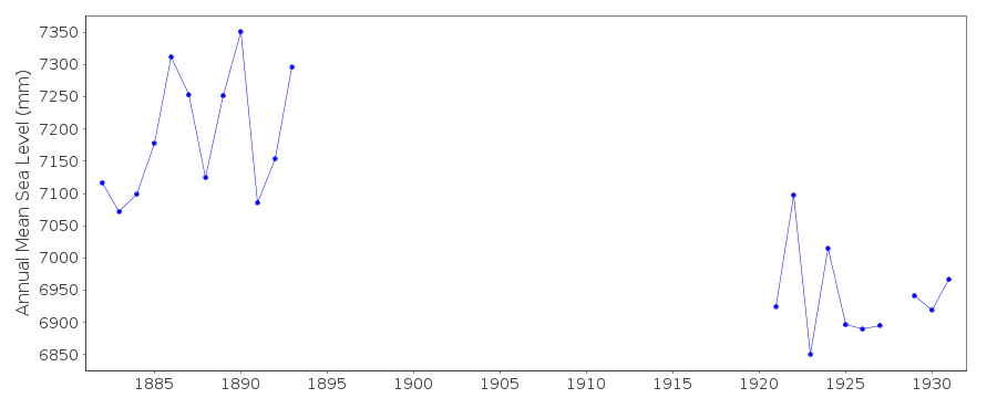 PSMSL Monthly Mean Sea Level for '48' 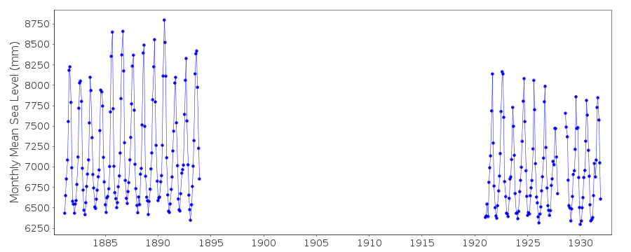
|
|
|