 |
SEALEVEL STATION CATALOG (SSC) |
|
|
|
|
|
| Station catalog metadata [edit] | [station overview] |
|---|
| SSC ID | SSC-kava | | Station Name | Kavalla | | Country | Greece | | Latitude | 40.934639 | | Longitude | 24.412133 | | DateLastModified | 2015-10-22 19:02:29 |
| Linked codes |
|---|
| Codes | Location | Latitude | Longitude | Sensors | PSMSL: 375 | KAVALLA | 40.934639 | 24.412133 | N/A |
| Distributed metadata source: PSMSL |
| Name | KAVALLA |
| SONEL id | 4155 |
| Is RLR | Y |
| Has RLR Diagram | Y link |
| QC Flag | N |
| Old ID | 290/061 |
| Last Updated | 2026-03-13 |
| Supplier | HELLENIC NAVY HYDROGRAPHIC SERVICE |
| Address | Hellenic Navy Hydrographic Service, Geographic Policy and International Relations Office, TGN 1040, Athens, GREECE |
| Metric Start | 1933 |
| Metric End | 2025 |
| Metric Completeness | 52.8 |
| RLR Start | 1969 |
| RLR End | 2025 |
| RLR Completeness | 70.5 |
| Download metric sea level data. | Use only with extreme caution. |
PSMSL Annual Mean Sea Level for '375' 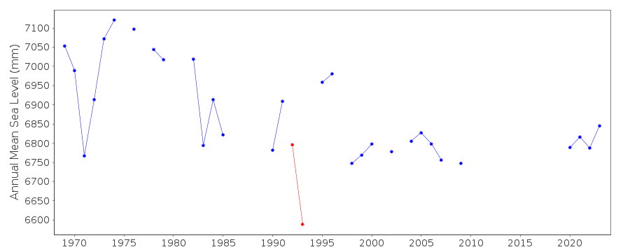 PSMSL Monthly Mean Sea Level for '375' 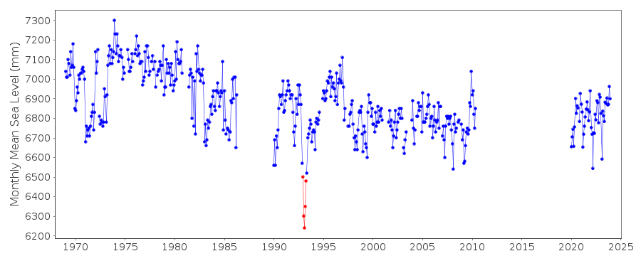
|
|
|