 |
SEALEVEL STATION CATALOG (SSC) |
|
|
|
|
|
| Station catalog metadata [edit] | [station overview] |
|---|
| SSC ID | SSC-hirom | | Station Name | Hirosima | | Country | Japan | | Latitude | 34.353056 | | Longitude | 132.464722 | | DateLastModified | 2015-10-22 19:02:29 |
| Linked codes |
|---|
| Codes | Location | Latitude | Longitude | Sensors | PSMSL: 1028 | HIROSIMA | 34.353056 | 132.464722 | N/A |
| Distributed metadata source: PSMSL |
| Name | HIROSIMA |
| Is RLR | Y |
| Has RLR Diagram | Y link |
| QC Flag | N |
| Old ID | 643/044 |
| Last Updated | 2023-02-03 |
| Supplier | JAPAN OCEANOGRAPHIC DATA CENTRE, M.S.A. |
| Address | Japan Oceanographic Data Centre, Hydrographic Department, Maritime Safety Agency, MLIT Aomi Building, 2-5-18, Aomi, Koto-ku, Tokyo 135-0064, JAPAN |
| Metric Start | 1963 |
| Metric End | 2022 |
| Metric Completeness | 96.3 |
| RLR Start | 1963 |
| RLR End | 2022 |
| RLR Completeness | 96.3 |
| Download metric sea level data. | Use only with extreme caution. |
PSMSL Annual Mean Sea Level for '1028' 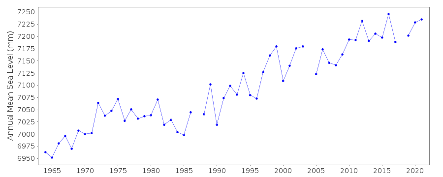 PSMSL Monthly Mean Sea Level for '1028' 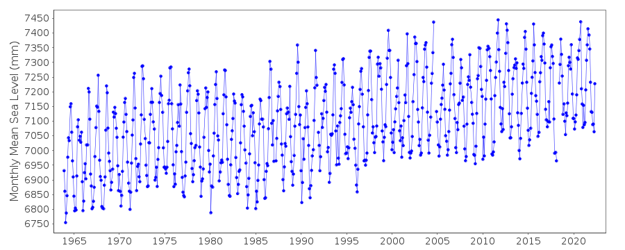
|
|
|