 |
SEALEVEL STATION CATALOG (SSC) |
|
|
|
|
|
| Station catalog metadata [edit] | [station overview] |
|---|
| SSC ID | SSC-hali | | Station Name | Halifax | | Country | Canada | | Latitude | 44.67 | | Longitude | -63.58 | | DateLastModified | 2015-10-22 19:02:29 |
| Distributed metadata source: IOC Sea Level Station Monitoring Facility hali |
|---|
| Status | Down |
| Local Contact | Fisheries and Oceans Canada ( Canada ) |
| Connection | FTP box |
| Country | Canada |
| Sensor 1 | |
| Type of sensor | enc |
| Sampling rate (min) | 1 |
| Distributed metadata source: GLOSS Station Handbook |
|---|
| Time Zone | 060W, GMT - 4hrs | | Ocean | Atlantic | | Operational | Yes | | Responsible country | Canada | | Tide gauge benchmarks | WSC1-1981 A Water Survey of Canada tablet set horizontally in the NE face of the SE corner of bldg. no. D-57, tablet 0.76m N of SE corner 0.15m below brickwork. Elevation 5.094m above Chart Datum (LNT). | | Benchmark relationships | 1895-1907 Admiralty Datum of 25.58m (Admiralty assumed datum) *see below
1919-1939 Admiralty Datum of 25.58m (Admiralty assumed datum) *see below
1940-1955 Admiralty Datum of 25.58m (Admiralty assumed datum) *see below
1956- to date Canadian Hygrographic | | Auxiliary benchmarks | WSC2-1981: A Water Survey of Canada tablet set horizontally in the NE face of the NW corner of bldg. no. D-34, tablet 2.84m from N corner of bldg. and 0.30m above concrete walkway. Elevation 4.766m above LNT.
88N9000: A CHS tablet set horizontally in the SE corner of the new naval fire station foundation, 0.24m west of the SE corner of the bldg., 0.14m below brickwork. Elevation 8.208m above Chart Datum (LNT).
96N9000: A CHS set horizontally in the south face of the SW bridge (Angus L. Macdonald) caisson, 0.10m above granite sill, 0.20m east of the SW corner of the caisson, 0.80m above paved ground level surface and 15.0m NNW of gauge house. Elevation 4.278m above Chart Datum.
| | Other relevant information | Data available at http://www.waterlevels.gc.ca, http://www.meds-sdmm.dfo-mpo.gc.ca/meds/Databases/TWL/TWL_inventory_e.htm and http://www.meds-sdmm.dfo-mpo.gc.ca/meds/prog_nat/benchmark/public/default_e.as | | Other relevant codes | UHSLC 275 | | Nearest Met. station | Bedford, Nova Scotia |
| Distributed metadata source: UHSLC |
| UHSLC id | 275 |
| SSC id | hali |
| GLOSS id | 222 |
| UHSLC geojson | https://uhslc.soest.hawaii.edu/data/meta.geojson |
| Research quality data version a | 1895-10-16 - 2014-08-12 |
| RQ basin | atlantic |
| Fast delivery | 1895-10-16 - 2021-04-05 |
| Distributed metadata source: PSMSL |
| Name | BEDFORD INSTITUTE |
| UHSLC ID | 275 |
| Is RLR | Y |
| Has RLR Diagram | Y link |
| QC Flag | N |
| Old ID | 970/012 |
| Last Updated | 2025-06-19 |
| Supplier | CANADIAN HYDROGRAPHIC SERVICE |
| Address | Canadian Hydrographic Service, 615 Booth Street, Ottawa , Ontario K1A 0E6, CANADA |
| Metric Start | 2003 |
| Metric End | 2024 |
| Metric Completeness | 87.1 |
| RLR Start | 2003 |
| RLR End | 2024 |
| RLR Completeness | 87.1 |
| Download metric sea level data. | Use only with extreme caution. |
| Name | HALIFAX |
| GLOSS id | 222 |
| UHSLC ID | 275 |
| SONEL id | 692 |
| Is RLR | Y |
| Has RLR Diagram | Y link |
| QC Flag | N |
| Old ID | 970/011 |
| Last Updated | 2017-06-29 |
| Supplier | CANADIAN HYDROGRAPHIC SERVICE |
| Address | Canadian Hydrographic Service, 615 Booth Street, Ottawa , Ontario K1A 0E6, CANADA |
| Metric Start | 1895 |
| Metric End | 2014 |
| Metric Completeness | 78.6 |
| RLR Start | 1895 |
| RLR End | 2014 |
| RLR Completeness | 78.6 |
| Download metric sea level data. | Use only with extreme caution. |
IOC Sea Level Station Monitoring Facility - realtime graph for 'hali'  PSMSL Annual Mean Sea Level for '2352' 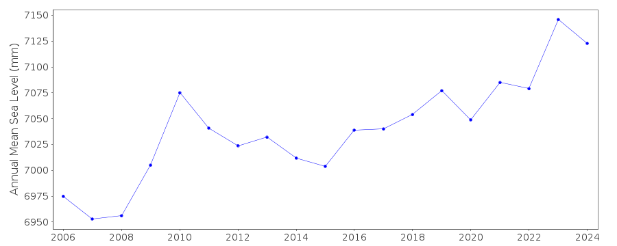 PSMSL Annual Mean Sea Level for '96' 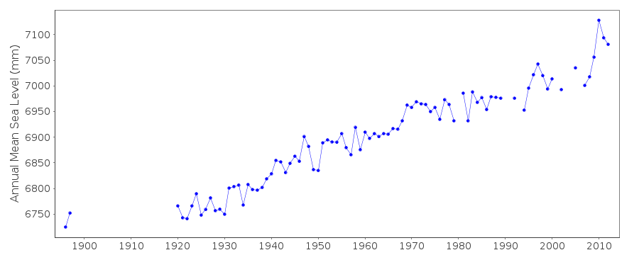 PSMSL Monthly Mean Sea Level for '96' 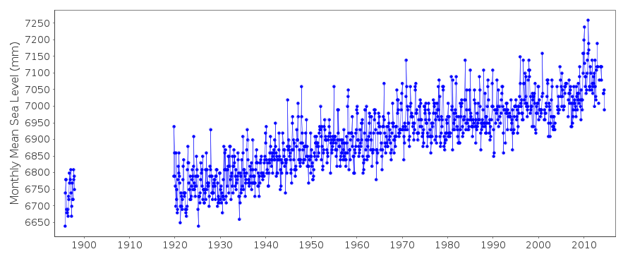
|
|
|