 |
SEALEVEL STATION CATALOG (SSC) |
|
|
|
|
|
| Station catalog metadata [edit] | [station overview] |
|---|
| SSC ID | SSC-haif | | Station Name | Haifa | | Country | Israel | | Latitude | 32.816667 | | Longitude | 35 | | DateLastModified | 2015-10-22 19:02:29 |
| Distributed metadata source: IOC Sea Level Station Monitoring Facility haif |
|---|
| GTS station code | HAIF |
| GTS message type | SXXX33 |
| Status | Down |
| Local Contact | Joint Research Centre ( Europe ) |
| Other Contact | Israel Oceanographic and Limnological Research Ltd ( Israel ) |
| Connection | BGAN |
| Country | Israel |
| Sensor 1 | |
| Type of sensor | rad |
| Sampling rate (min) | 1 |
| Distributed metadata source: PTWC COMP META file |
| DCP ID | HAIF |
| WMO | SXXX33 |
| Samp Rate | 1 |
| Num# Samp | 10 |
| Unit | M |
| Scale | 1.0000 |
| Xmt Int. | 005 |
| Fst Min. | 0004 |
| HAR | 0 |
| Owner | JRC |
| Distributed metadata source: PSMSL |
| Name | HAIFA II |
| Is RLR | Y |
| Has RLR Diagram | Y link |
| QC Flag | N |
| Old ID | 320/010 |
| Last Updated | 2019-07-23 |
| Supplier | SURVEY OF ISRAEL |
| Address | Research Department, Survey of Israel, 1 Lincoln Street, Tel Aviv 65200, ISRAEL |
| Metric Start | 2013 |
| Metric End | 2018 |
| Metric Completeness | 84.7 |
| RLR Start | 2013 |
| RLR End | 2018 |
| RLR Completeness | 84.7 |
| Download metric sea level data. | Use only with extreme caution. |
| Name | HAIFA |
| SONEL id | 2619 |
| Is RLR | N |
| Has RLR Diagram | N link |
| QC Flag | N |
| Old ID | 320/011 |
| Last Updated | null |
| Supplier | ISRAEL PORTS AUTHORITY |
| Address | Coast Study Division, Israel Ports Authority, P.O.B. 5, Ashdod, ISRAEL |
| Metric Start | 1956 |
| Metric End | 1976 |
| Metric Completeness | 69.8 |
| Download metric sea level data. | Use only with extreme caution. |
IOC Sea Level Station Monitoring Facility - realtime graph for 'haif'  PSMSL Annual Mean Sea Level for '2221' 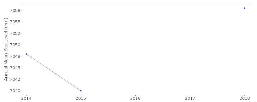 PSMSL Annual Mean Sea Level for '798'  PSMSL Monthly Mean Sea Level for '798' 
|
|
|