 |
SEALEVEL STATION CATALOG (SSC) |
|
|
|
|
|
| Station catalog metadata [edit] | [station overview] |
|---|
| SSC ID | SSC-hade | | Station Name | Hadera | | Country | Israel | | Latitude | 32.47053 | | Longitude | 34.863057 | | DateLastModified | 2015-10-22 19:02:29 |
| Distributed metadata source: IOC Sea Level Station Monitoring Facility hade |
|---|
| Status | Down |
| Local Contact | Israel Oceanographic and Limnological Research Ltd ( Israel ) |
| Connection | FTP box |
| Country | Israel |
| Sensor 1 | |
| Type of sensor | prs |
| Sampling rate (min) | 0.25 |
| Distributed metadata source: IOC Sea Level Station Monitoring Facility hade2 |
|---|
| GTS station code | HADE2 |
| GTS message type | SXXX33 |
| Status | Down |
| Local Contact | Joint Research Centre ( Europe ) |
| Other Contact | Israel Oceanographic and Limnological Research Ltd ( Israel ) |
| Connection | BGAN |
| Country | Israel |
| Sensor 1 | |
| Type of sensor | rad |
| Sampling rate (min) | 1 |
| Distributed metadata source: GLOSS Station Handbook |
|---|
| Time Zone | 000E, GMT | | Operational | Yes | | Responsible country | Israel | | Additional parameters | Sea/air temp., currents, waves, atmospheric pressure, winds | | Tide gauge benchmarks | 0013: Dolphin point (32 28N, 34 52E), stainless steel, epoxy coated bolt on dolphin concrete capping platform. Elevation (H) of benchmark & local undulation (N) are 6.187m and 34.786m respectively (WGS-84 datum). | | Benchmark relationships | Data are referenced to the zero of the land survey datum of Israel.
Tide gauge zero (TGZ) = 18.00m below TGBM 0013.
TGZ = 11.50m below Israel Land Survey Datum
| | Auxiliary benchmarks | 0012: Land control benchmark (32 28N, 34 53E), on top of water storage tank, H=16.132m, N=34.821m. Height difference from 0012 to 0013 (1991) orthometric diff.=9.945m, ellipsoidal diff.=9.980m; (1993) ellipsoidal diff.=9.983m.
Three other precise levelling points in Israel Land Survey Network (0745, 0746 and 4462) are located nearby.
| | Other relevant information | The dolphin used was loaded in 1980 with 900 metric ton for soil resistance testing & is estimated to have reached complete consolidation.
The location of the Hadera station is estimated by some local geologiststo have been stable for the past 2000 years, on the basis of available geological data.
| | Nearest Met. station | Hadera Port, Israel |
| Distributed metadata source: PSMSL |
| Name | HADERA |
| GLOSS id | 80 |
| SONEL id | 2022 |
| Is RLR | Y |
| Has RLR Diagram | Y link |
| QC Flag | N |
| Old ID | 320/016 |
| Last Updated | 2026-07-06 |
| Supplier | ISRAEL OCEANOGRAPHIC AND LIMNOLOGICAL RES. LTD. |
| Address | Israel Oceanographic and Limnological Research Ltd., Tel Shikmona, P.O. Box 8030, Haifa 31080, ISRAEL |
| Metric Start | 1992 |
| Metric End | 2025 |
| Metric Completeness | 87.5 |
| RLR Start | 1992 |
| RLR End | 2025 |
| RLR Completeness | 87.5 |
| Download metric sea level data. | Use only with extreme caution. |
IOC Sea Level Station Monitoring Facility - realtime graph for 'hade'  IOC Sea Level Station Monitoring Facility - realtime graph for 'hade2'  PSMSL Annual Mean Sea Level for '1797' 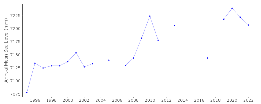 PSMSL Monthly Mean Sea Level for '1797' 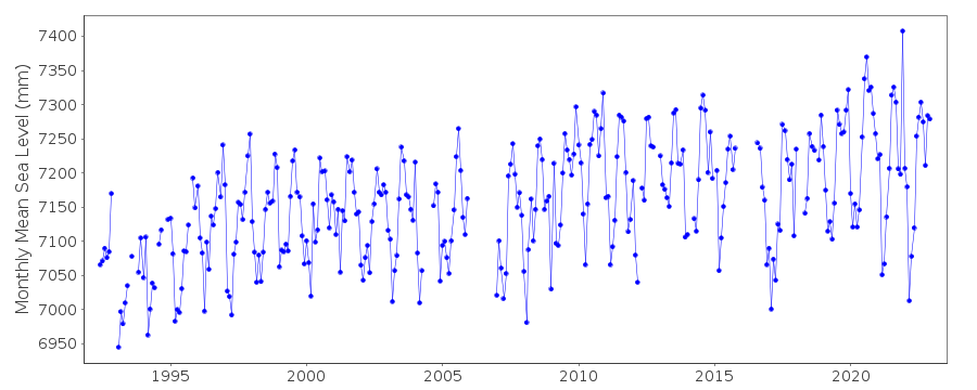
|
|
|