| Station catalog metadata [edit] | [station overview] |
|---|
| SSC ID | SSC-ftfr |
| Station Name | Fort-de-France |
| Country | France |
| Latitude | 14.601667 |
| Longitude | -61.063333 |
| DateLastModified | 2015-10-22 19:02:29 |
| Linked codes |
|---|
| Codes | Location | Latitude | Longitude | Sensors |
IOC: ftfr | Fort-de-France, Martinique | 14.601667 | -61.063333 | rad |
IOC: ftfr2 | Fort-de-France, Martinique 2 | 14.601667 | -61.063333 | rad |
GLOSS: 338 | Fort-de-France | 14.58333 | -61.05 | Radar |
PTWC: ftfr | Fort_de_France_MQ | 14.6017 | -61.0633 | rad |
PSMSL: 1582 | FORT-DE-FRANCE | 14.6 | -61.083333 | N/A |
PSMSL: 1942 | FORT-DE-FRANCE II | 14.6015 | -61.063202 | N/A |
SONEL_GPS: 2503 | FORT-DE-FRANCE | 14.59481631 | -60.99617063 | N/A |
SONEL_GPS: 3220 | FORT-DE-FRANCE | 14.60149956 | -61.06320190 | N/A |
SONEL_TG: 1764 | FORT-DE-FRANCE | 14.60149956 | -61.06320190 | N/A |
| Distributed metadata source: IOC Sea Level Station Monitoring Facility ftfr |
|---|
| Status | Operational |
| Local Contact | Service hydrographique et océanographique de la marine ( France ) |
| Connection | FTP box |
| Country | France |
| Sensor 1 | |
| Type of sensor | rad |
| Sampling rate (min) | 1 |
| Distributed metadata source: IOC Sea Level Station Monitoring Facility ftfr2 |
|---|
| GTS station code | FR126 |
| GTS message type | SZCA01 |
| Status | Operational |
| Local Contact | Service hydrographique et océanographique de la marine ( France ) |
| Other Contact | International Tsunami Information Center Caribbean Office ( USA ) |
| Connection | GTS message |
| Country | France |
| Sensor 1 | |
| Type of sensor | rad |
| Sampling rate (min) | 1 |
| Distributed metadata source: GLOSS Station Handbook |
|---|
| Time Zone | GMT -4hrs |
| Additional parameters | Meteo: Pressure |
| Tide gauge benchmarks | The radar tige gauge was installed by SHOM in October 2005. |
| Other relevant information | The tide gauge is operated in collaboration with the local authorities of Meteo- France and the French Navy.
No Real- Time
Digital: Yes
Precision: 1cm
Control: Semestrial
Levelling: 2005 |
| Distributed metadata source: PTWC COMP META file |
| DCP ID | 186AA7DE |
| WMO | SZCA01 |
| Samp Rate | 1 |
| Num# Samp | 12 |
| Unit | M |
| Scale | 1.0000 |
| Xmt Int. | 006 |
| Fst Min. | 0001 |
| HAR | 1 |
| Owner | SHOM |
| Distributed metadata source: PSMSL |
| Name | FORT-DE-FRANCE |
| GLOSS id | 338 |
| UHSLC ID | 271 |
| Is RLR | N |
| Has RLR Diagram | N link |
| QC Flag | N |
| Old ID | 912/011 |
| Last Updated | 1987-05-19 |
| Supplier | SERVICE HYD. ET OCEAN. DE LA MARINE |
| Address | SHOM, 13 rue de Chatelier, 29200 BREST , FRANCE |
| Metric Start | 1983 |
| Metric End | 1985 |
| Metric Completeness | 77.8 |
| Download metric sea level data. | Use only with extreme caution. |
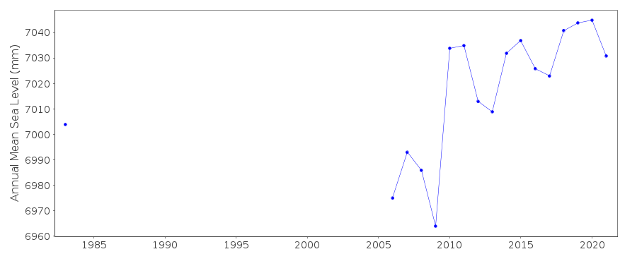
| Name | FORT-DE-FRANCE II |
| GLOSS id | 338 |
| UHSLC ID | 271 |
| SONEL id | 2503 |
| Is RLR | Y |
| Has RLR Diagram | Y link |
| QC Flag | N |
| Old ID | 912/021 |
| Last Updated | 2026-02-20 |
| Supplier | SERVICE HYD. ET OCEAN. DE LA MARINE |
| Address | SHOM, 13 rue de Chatelier, 29200 BREST , FRANCE |
| Metric Start | 1976 |
| Metric End | 2025 |
| Metric Completeness | 45.7 |
| RLR Start | 1976 |
| RLR End | 2025 |
| RLR Completeness | 45.7 |
| Download metric sea level data. | Use only with extreme caution. |
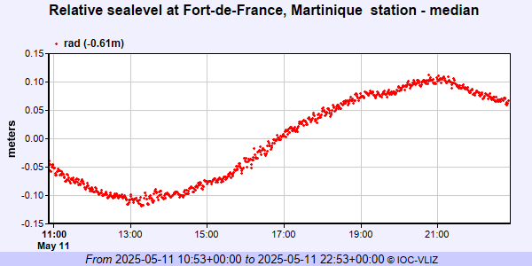
IOC Sea Level Station Monitoring Facility - realtime graph for 'ftfr'
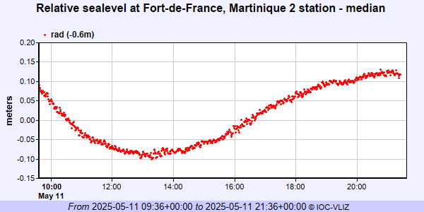
IOC Sea Level Station Monitoring Facility - realtime graph for 'ftfr2'
PSMSL Annual Mean Sea Level for '1582'

PSMSL Annual Mean Sea Level for '1942'
PSMSL Monthly Mean Sea Level for '1942'

