 |
SEALEVEL STATION CATALOG (SSC) |
|
|
|
|
|
| Station catalog metadata [edit] | [station overview] |
|---|
| SSC ID | SSC-fptx | | Station Name | Free Port | | Country | United States | | Latitude | 28.95 | | Longitude | -95.31 | | DateLastModified | 2015-10-22 19:02:29 |
| Linked codes |
|---|
| Codes | Location | Latitude | Longitude | Sensors | IOC: fptx | Free_Port_TX | 28.95 | -95.31 | pwl, bwl |
PTWC: fptx | | | | |
PSMSL: 2297 | USCG FREEPORT, TEXAS | 28.943333 | -95.301667 | N/A |
PSMSL: 725 | FREEPORT | 28.948333 | -95.308333 | N/A |
| Distributed metadata source: IOC Sea Level Station Monitoring Facility fptx |
|---|
| GTS station code | 3368E1DE |
| GTS message type | SXXX03 |
| Status | Operational |
| Local Contact | National Ocean Service-NOAA ( USA ) |
| Country | USA |
| Sensor 1 | |
| Type of sensor | pwl |
| Sampling rate (min) | 1 |
| Sensor 2 | |
| Type of sensor | bwl |
| Sampling rate (min) | 6 |
| Distributed metadata source: PTWC COMP META file |
| DCP ID | |
| WMO | |
| Samp Rate | |
| Num# Samp | |
| Unit | |
| Scale | |
| Xmt Int. | |
| Fst Min. | |
| HAR | |
| Owner | |
| Distributed metadata source: PSMSL |
| Name | USCG FREEPORT, TEXAS |
| SONEL id | 3519 |
| Is RLR | Y |
| Has RLR Diagram | Y link |
| QC Flag | N |
| Old ID | 940/012 |
| Last Updated | 2021-02-02 |
| Supplier | N.O.A.A. / N.O.S. |
| Address | N.O.A.A. / N.O.S., N/oes33, Ssmc4, Room 6531, 1305 East-West Highway, Silver Spring, , MD 20910, UNITED STATES |
| Metric Start | 2006 |
| Metric End | 2020 |
| Metric Completeness | 89.4 |
| RLR Start | 2006 |
| RLR End | 2020 |
| RLR Completeness | 89.4 |
| Download metric sea level data. | Use only with extreme caution. |
| Name | FREEPORT |
| SONEL id | 3519 |
| Is RLR | Y |
| Has RLR Diagram | Y link |
| QC Flag | N |
| Old ID | 940/006 |
| Last Updated | 2009-05-27 |
| Supplier | N.O.A.A. / N.O.S. |
| Address | N.O.A.A. / N.O.S., N/oes33, Ssmc4, Room 6531, 1305 East-West Highway, Silver Spring, , MD 20910, UNITED STATES |
| Metric Start | 1954 |
| Metric End | 2008 |
| Metric Completeness | 97.0 |
| RLR Start | 1954 |
| RLR End | 2008 |
| RLR Completeness | 97.0 |
| Download metric sea level data. | Use only with extreme caution. |
IOC Sea Level Station Monitoring Facility - realtime graph for 'fptx'  PSMSL Annual Mean Sea Level for '2297' 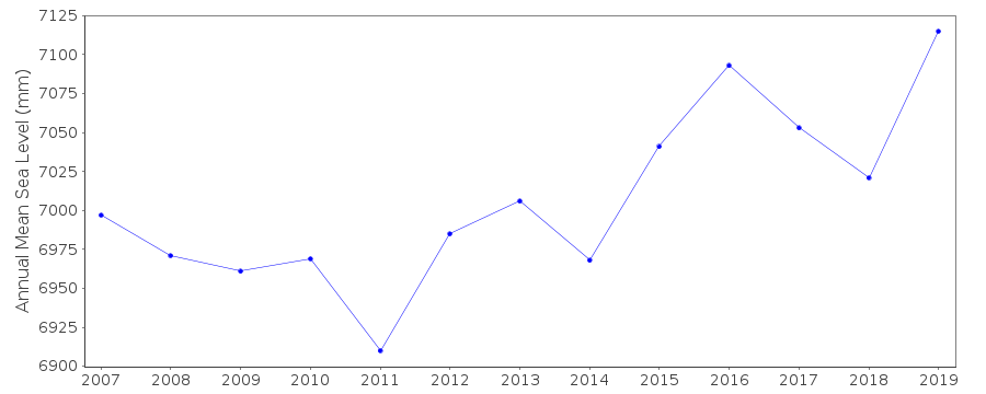 PSMSL Annual Mean Sea Level for '725' 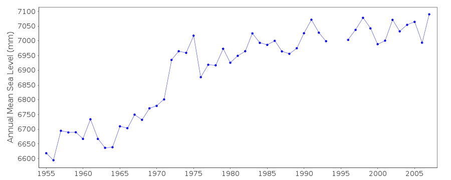 PSMSL Monthly Mean Sea Level for '725' 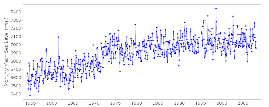
|
|
|