 |
SEALEVEL STATION CATALOG (SSC) |
|
|
|
|
|
| Station catalog metadata [edit] | [station overview] |
|---|
| SSC ID | SSC-fong | | Station Name | Fongafale | | Country | Tuvalu | | Latitude | -8.5033 | | Longitude | 179.1949 | | DateLastModified | 2022-09-13 06:34:37 |
| Distributed metadata source: IOC Sea Level Station Monitoring Facility fong |
|---|
| GTS station code | 67440 |
| GTS message type | SZPS01 |
| Status | Operational |
| Other Contact | National Tidal Centre/Australian Bureau of Meteorology ( Australia ) |
| Connection | GTS message |
| Country | Tuvalu Islands |
| Sensor 1 | |
| Type of sensor | aqu |
| Sampling rate (min) | 1 |
| Distributed metadata source: GLOSS Station Handbook |
|---|
| Time Zone | 180E, GMT + 12hrs | | Ocean | Pacific | | Operational | Yes | | Responsible country | Australia | | Data acquisition rate | 6 minute intervals | | Additional parameters | Barometric pressure, water and air temperature, wind speed and direction. | | Tide gauge benchmarks | UH1: SS disc set in concrete 1ft from SW corner of tide gauge catwalk and 1ft from edge of quay. | | Auxiliary benchmarks | UH2: SS disc set in concrete stamped 'UH-2' 70ft E of mark UH1, 8 inches from edge of quay and 15ft from NE corner of quay.
UH3: SS disc in the SE corner of ramp approaching the power house 100ft E of quay.
TP1: SS hex bolt set in white epoxy located 190ft N on shoreline road from UH3 & set 12ft E of road & 30ft from NW corner of Ag. Office.
. | | Other relevant information | Backup gauges on site: 1) Leupold Stevens ADR (August 1986-)
2) Handar Encoder (August 1986-)
Daily values calculated using 119-point convolution filter (Bloomfield, 1976) centred on noon applied to the hourly data with respective periods of the 95, 50 and 5% amplitude points at 124.0, 60.2 and 40.2 hours.
| | Other relevant codes | NTF port no. 67440, UHSLC 025 |
| Distributed metadata source: PTWC COMP META file |
| DCP ID | 67440 |
| WMO | SZPS01 |
| Samp Rate | 1 |
| Num# Samp | 6 |
| Unit | M |
| Scale | 1.0000 |
| Xmt Int. | 003 |
| Fst Min. | 0000 |
| HAR | 1 |
| Owner | ABM |
| Distributed metadata source: UHSLC |
| UHSLC id | 025 |
| SSC id | funa |
| GLOSS id | 121 |
| UHSLC geojson | https://uhslc.soest.hawaii.edu/data/meta.geojson |
| Research quality data version a | 1977-10-17 - 1999-12-31 |
| Research quality data version b | 1993-03-24 - 2021-12-31 |
| RQ basin | pacific |
| Fast delivery | 1993-03-24 - 2026-05-31 |
| Distributed metadata source: PSMSL |
| Name | FUNAFUTI |
| GLOSS id | 121 |
| UHSLC ID | 25 |
| Is RLR | Y |
| Has RLR Diagram | Y link |
| QC Flag | N |
| Old ID | 732/011 |
| Last Updated | 2001-03-21 |
| Supplier | UNIVERSITY OF HAWAII SEA LEVEL CENTER |
| Address | University of Hawaii Sea Level Center, Department of Oceanography Division of Natural Sciences, 1000 Pope Road, Honolulu, Hawaii 96822, UNITED STATES |
| Metric Start | 1977 |
| Metric End | 1999 |
| Metric Completeness | 92.4 |
| RLR Start | 1977 |
| RLR End | 1999 |
| RLR Completeness | 92.4 |
| Download metric sea level data. | Use only with extreme caution. |
| Name | FUNAFUTI B |
| GLOSS id | 121 |
| UHSLC ID | 25 |
| SONEL id | 865 |
| Is RLR | Y |
| Has RLR Diagram | Y link |
| QC Flag | N |
| Old ID | 732/012 |
| Last Updated | 2026-06-01 |
| Supplier | NATIONAL TIDAL CENTRE |
| Address | National Tidal Centre, Bureau of Meteorology, PO Box 421, Kent Town 5071, South Australia, AUSTRALIA |
| Metric Start | 1993 |
| Metric End | 2026 |
| Metric Completeness | 92.9 |
| RLR Start | 1993 |
| RLR End | 2026 |
| RLR Completeness | 92.9 |
| Download metric sea level data. | Use only with extreme caution. |
IOC Sea Level Station Monitoring Facility - realtime graph for 'fong' 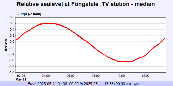 PSMSL Annual Mean Sea Level for '1452' 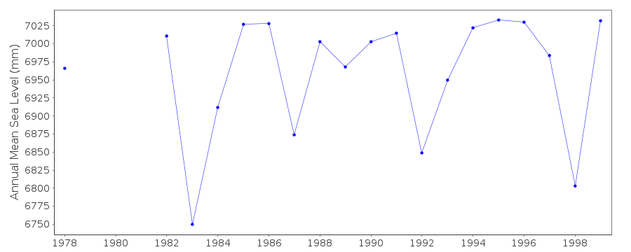 PSMSL Annual Mean Sea Level for '1839' 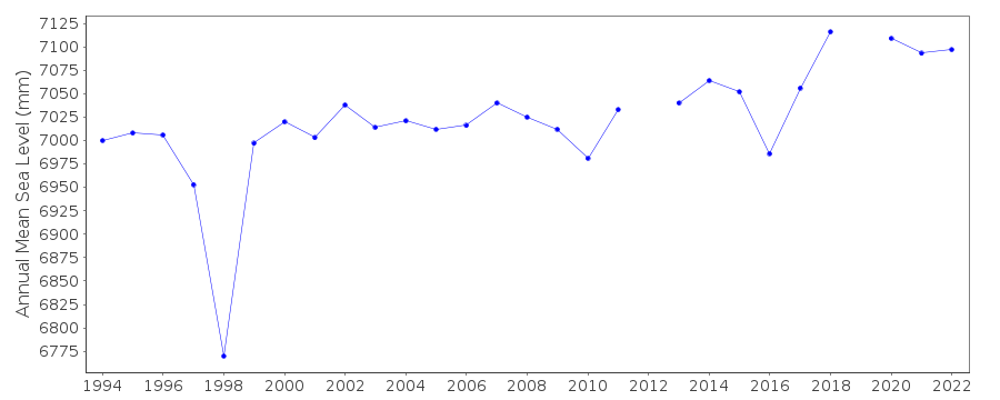 PSMSL Monthly Mean Sea Level for '1839' 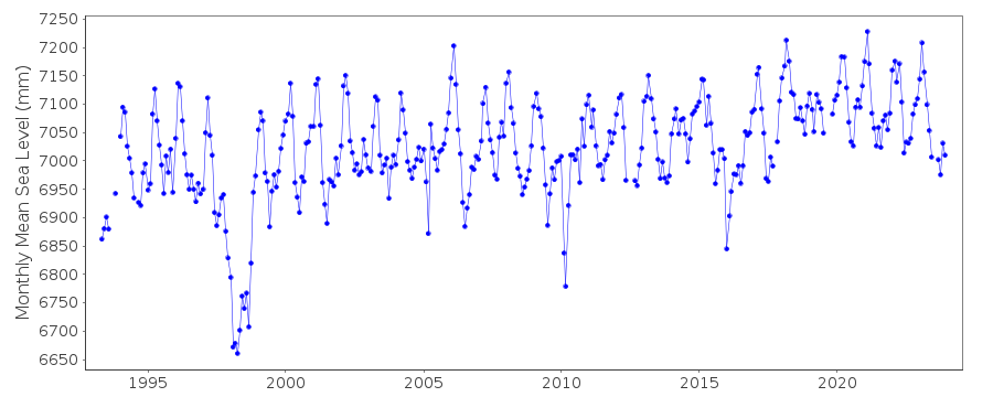
|
|
|