 |
SEALEVEL STATION CATALOG (SSC) |
|
|
|
|
|
| Station catalog metadata [edit] | [station overview] |
|---|
| SSC ID | SSC-ferg | | Station Name | Cape Ferguson | | Country | Australia | | Latitude | -19.2773 | | Longitude | 147.0584 | | DateLastModified | 2015-10-22 19:02:29 |
| Distributed metadata source: IOC Sea Level Station Monitoring Facility ferg |
|---|
| GTS station code | 59260 |
| GTS message type | SZAU01 |
| Status | Operational |
| Local Contact | National Tidal Centre/Australian Bureau of Meteorology ( Australia ) |
| Connection | GTS message |
| Country | Australia |
| Sensor 1 | |
| Type of sensor | aqu |
| Sampling rate (min) | 1 |
| Distributed metadata source: GLOSS Station Handbook |
|---|
| Time Zone | 150E, GMT + 10hrs | | Ocean | Pacific | | Operational | Yes | | Responsible country | Australia | | Data acquisition rate | 10 minute recording interval | | Tide gauge benchmarks | NMV/B/309A: Brass rod in concrete footing of elevated loading conveyor on concrete Wharf No. 6 (PSM 19533). | | Benchmark relationships | Tide Gauge Zero (TGZ) = 6.379m below NMV/B/309A.
TGZ = 9.025m below BM 10011.
TGZ = 1.856m below Australian Height Datum (AHD). | | Auxiliary benchmarks | BM 10011: NE corner of State Offices, Wickham Street, Townsville.
NMV/B/310A: Brass rod in concrete near edge of Wharf No.6 (PSM 19534).
TPA Master BM: Brass rod in concrete under steel plate, Wharf No.4 (PSM 47788).
PSM 100028: Permanent survey plaque in concrete at base, Wharf No.4.
| | Other relevant information | Queensland Beach Protection Authority operates analogue and digital recorders on nearby Ro-Ro Wharf.
CIGNET station planned for Townsville - GPS survey completed in October 1990.
| | Other relevant codes | NTF port no. 59250, UHSLC 334 |
| Distributed metadata source: PTWC COMP META file |
| DCP ID | 59260 |
| WMO | SZAU01 |
| Samp Rate | 1 |
| Num# Samp | 6 |
| Unit | M |
| Scale | 1.0000 |
| Xmt Int. | 003 |
| Fst Min. | 0000 |
| HAR | 1 |
| Owner | ABM |
| Distributed metadata source: UHSLC |
| UHSLC id | 334 |
| SSC id | town |
| GLOSS id | 60 |
| UHSLC geojson | https://uhslc.soest.hawaii.edu/data/meta.geojson |
| Research quality data version a | 1984-01-01 - 2021-12-31 |
| RQ basin | pacific |
| Fast delivery | 1984-01-01 - 2026-05-31 |
| UHSLC id | 343 |
| SSC id | ferg |
| UHSLC geojson | https://uhslc.soest.hawaii.edu/data/meta.geojson |
| Research quality data version a | 1991-09-12 - 2021-12-31 |
| RQ basin | pacific |
| Distributed metadata source: PSMSL |
| Name | CAPE FERGUSON |
| UHSLC ID | 343 |
| SONEL id | 858 |
| Is RLR | Y |
| Has RLR Diagram | Y link |
| QC Flag | N |
| Old ID | 680/054 |
| Last Updated | 2026-06-01 |
| Supplier | NATIONAL TIDAL CENTRE |
| Address | National Tidal Centre, Bureau of Meteorology, PO Box 421, Kent Town 5071, South Australia, AUSTRALIA |
| Metric Start | 1979 |
| Metric End | 2025 |
| Metric Completeness | 87.2 |
| RLR Start | 1992 |
| RLR End | 2025 |
| RLR Completeness | 96.1 |
| Download metric sea level data. | Use only with extreme caution. |
| Name | TOWNSVILLE II |
| GLOSS id | 60 |
| UHSLC ID | 334 |
| Is RLR | N |
| Has RLR Diagram | N link |
| QC Flag | N |
| Old ID | 680/052 |
| Last Updated | null |
| Supplier | QUEENSLAND D.O.T. |
| Address | Queensland D.O.T., Maritime Division, G.P.O. Box 2595, Brisbane, Queensland, AUSTRALIA |
| Metric Start | 1949 |
| Metric End | 1960 |
| Metric Completeness | 98.6 |
| Download metric sea level data. | Use only with extreme caution. |
| Name | TOWNSVILLE I |
| GLOSS id | 60 |
| UHSLC ID | 334 |
| Is RLR | Y |
| Has RLR Diagram | Y link |
| QC Flag | N |
| Old ID | 680/051 |
| Last Updated | 2025-03-20 |
| Supplier | NATIONAL TIDAL CENTRE |
| Address | National Tidal Centre, Bureau of Meteorology, PO Box 421, Kent Town 5071, South Australia, AUSTRALIA |
| Metric Start | 1951 |
| Metric End | 2025 |
| Metric Completeness | 91.2 |
| RLR Start | 1959 |
| RLR End | 2025 |
| RLR Completeness | 98.4 |
| Download metric sea level data. | Use only with extreme caution. |
| Name | TOWNSVILLE III |
| GLOSS id | 60 |
| UHSLC ID | 334 |
| Is RLR | N |
| Has RLR Diagram | N link |
| QC Flag | N |
| Old ID | 680/053 |
| Last Updated | 1993-05-24 |
| Supplier | NATIONAL TIDAL FACILITY |
| Address | National Tidal Facility, G.P.O. Box 2100, S.A. 5001, Adelaide , AUSTRALIA |
| Metric Start | 1960 |
| Metric End | 1990 |
| Metric Completeness | 81.2 |
| Download metric sea level data. | Use only with extreme caution. |
IOC Sea Level Station Monitoring Facility - realtime graph for 'ferg'  PSMSL Annual Mean Sea Level for '1492' 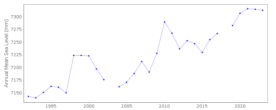 PSMSL Annual Mean Sea Level for '584'  PSMSL Annual Mean Sea Level for '637' 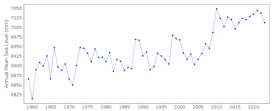 PSMSL Annual Mean Sea Level for '963'  PSMSL Monthly Mean Sea Level for '963' 
|
|
|