 |
SEALEVEL STATION CATALOG (SSC) |
|
|
|
|
|
| Station catalog metadata [edit] | [station overview] |
|---|
| SSC ID | SSC-espe | | Station Name | Esperance | | Country | Australia | | Latitude | -33.8709 | | Longitude | 121.8954 | | DateLastModified | 2015-10-22 19:02:29 |
| Distributed metadata source: IOC Sea Level Station Monitoring Facility espe |
|---|
| GTS station code | 62080 |
| GTS message type | SZAU01 |
| Status | Operational |
| Local Contact | National Tidal Centre/Australian Bureau of Meteorology ( Australia ) |
| Connection | GTS message |
| Country | Australia |
| Sensor 1 | |
| Type of sensor | aqu |
| Sampling rate (min) | 1 |
| Distributed metadata source: GLOSS Station Handbook |
|---|
| Time Zone | 120E, GMT + 8hrs | | Ocean | Southern | | Operational | Yes | | Responsible country | Australia | | Data acquisition rate | 6 minute interval | | Additional parameters | Barometric pressure, water/air temperature, wind speed and direction | | Tide gauge benchmarks | A PWD bronze plaque stamped 'TIDAL BM 1972', set in concrete deck at north west end of No. 1 berth. | | Benchmark relationships | Tide Gauge Zero (TGZ) = 3.944m below TGBM.
TGZ = 0.707m below Australian Height Datum (AHD)
| | Auxiliary benchmarks | HR4: A PWD bronze plaque in concrete sheet pile copping, No.1 berth.
NMV/F/2: Brass rod & identity tag in concrete base of the former front lead beacon.
NMV/F/3: Brass rod & identity tag in concrete block at NW corner of silo.
ESP33A: A standard L&S survey mark with concrete cover plate in cleared foreshore northwest of tide gauge.
Datum for AHD heights = 2.340m AHD
Esperence 172 = 64.824m AHD
Esperence 173 = 59.831m AHD
Esperence 171 = 58.339m AHD
Tide Esperence - SEAFRAME Sensor Benchmark = 4.075m AHD
Z1/73 = 4.036m AHD
| | Other relevant information | Gauge datum was lowered by 0.152m on 1 January 1972.
Geocentric measurements: Precise ephemeris, single point doppler fix, (Wireless) 1976.
PSMSL also hold data from another gauge at Esperance (PSMSL Code 680/447 1966-1985).
| | Other relevant codes | NTF port no. 62080, USHLC 176 | | Nearest Met. station | Esperance Met. Office |
| Distributed metadata source: PTWC COMP META file |
| DCP ID | 62080 |
| WMO | SZAU01 |
| Samp Rate | 1 |
| Num# Samp | 6 |
| Unit | M |
| Scale | 1.0000 |
| Xmt Int. | 003 |
| Fst Min. | 0000 |
| HAR | 1 |
| Owner | ABM |
| Distributed metadata source: UHSLC |
| UHSLC id | 176 |
| SSC id | espe |
| GLOSS id | 54 |
| UHSLC geojson | https://uhslc.soest.hawaii.edu/data/meta.geojson |
| Research quality data version a | 1985-01-01 - 2021-12-31 |
| RQ basin | indian |
| Fast delivery | 1985-01-01 - 2026-05-31 |
| Distributed metadata source: PSMSL |
| Name | ESPERANCE |
| GLOSS id | 54 |
| UHSLC ID | 176 |
| SONEL id | 2059 |
| Is RLR | Y |
| Has RLR Diagram | Y link |
| QC Flag | N |
| Old ID | 680/446 |
| Last Updated | 2025-03-20 |
| Supplier | NATIONAL TIDAL CENTRE |
| Address | National Tidal Centre, Bureau of Meteorology, PO Box 421, Kent Town 5071, South Australia, AUSTRALIA |
| Metric Start | 1965 |
| Metric End | 2025 |
| Metric Completeness | 95.5 |
| RLR Start | 1993 |
| RLR End | 2025 |
| RLR Completeness | 96.5 |
| Download metric sea level data. | Use only with extreme caution. |
| Name | ESPERANCE II |
| GLOSS id | 54 |
| UHSLC ID | 176 |
| Is RLR | N |
| Has RLR Diagram | N link |
| QC Flag | N |
| Old ID | 680/447 |
| Last Updated | 1993-05-24 |
| Supplier | NATIONAL TIDAL FACILITY |
| Address | National Tidal Facility, G.P.O. Box 2100, S.A. 5001, Adelaide , AUSTRALIA |
| Metric Start | 1965 |
| Metric End | 1989 |
| Metric Completeness | 84.7 |
| Download metric sea level data. | Use only with extreme caution. |
IOC Sea Level Station Monitoring Facility - realtime graph for 'espe' 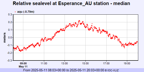 PSMSL Annual Mean Sea Level for '1114' 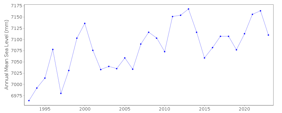 PSMSL Annual Mean Sea Level for '1127'  PSMSL Monthly Mean Sea Level for '1127' 
|
|
|