 |
SEALEVEL STATION CATALOG (SSC) |
|
|
|
|
|
| Station catalog metadata [edit] | [station overview] |
|---|
| SSC ID | SSC-dubl | | Station Name | Dublat, Saugor Island | | Country | India | | Latitude | 21.633333 | | Longitude | 88.133333 | | DateLastModified | 2015-10-22 19:02:29 |
| Linked codes |
|---|
| Codes | Location | Latitude | Longitude | Sensors | PSMSL: 417 | SAUGOR/SAGAR | 21.65 | 88.05 | N/A |
PSMSL: 49 | DUBLAT (SAUGOR IS.) | 21.633333 | 88.133333 | N/A |
| Distributed metadata source: PSMSL |
| Name | SAUGOR/SAGAR |
| Is RLR | Y |
| Has RLR Diagram | Y link |
| QC Flag | N |
| Old ID | 500/111 |
| Last Updated | 2016-01-27 |
| Supplier | SURVEY OF INDIA |
| Address | Survey of India, Geodetic and Research Branch, 17 E.C. Road, Dehra Dun , PIN 248 001, INDIA |
| Metric Start | 1937 |
| Metric End | 1988 |
| Metric Completeness | 94.9 |
| RLR Start | 1937 |
| RLR End | 1988 |
| RLR Completeness | 94.9 |
| Download metric sea level data. | Use only with extreme caution. |
| Name | DUBLAT (SAUGOR IS.) |
| Is RLR | Y |
| Has RLR Diagram | Y link |
| QC Flag | N |
| Old ID | 500/121 |
| Last Updated | null |
| Supplier | SURVEY OF INDIA |
| Address | Survey of India, Geodetic and Research Branch, 17 E.C. Road, Dehra Dun , PIN 248 001, INDIA |
| Metric Start | 1881 |
| Metric End | 1886 |
| Metric Completeness | 80.6 |
| RLR Start | 1881 |
| RLR End | 1886 |
| RLR Completeness | 80.6 |
| Download metric sea level data. | Use only with extreme caution. |
PSMSL Annual Mean Sea Level for '417' 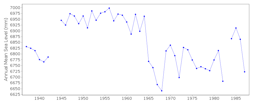 PSMSL Annual Mean Sea Level for '49' 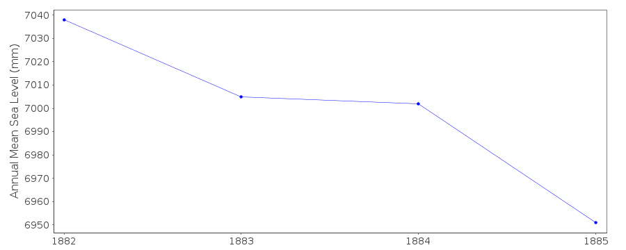 PSMSL Monthly Mean Sea Level for '49' 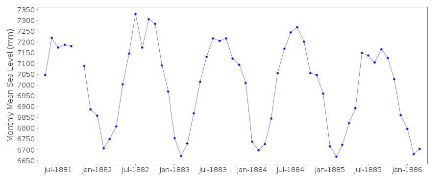
|
|
|