 |
SEALEVEL STATION CATALOG (SSC) |
|
|
|
|
|
| Station catalog metadata [edit] | [station overview] |
|---|
| SSC ID | SSC-dpnc | | Station Name | Duck Pier | | Country | United States | | Latitude | 36.1833 | | Longitude | -75.7466 | | DateLastModified | 2015-10-22 19:02:29 |
| Distributed metadata source: IOC Sea Level Station Monitoring Facility dpnc |
|---|
| GTS station code | 335DD5F4 |
| GTS message type | SXLA03 |
| Status | Operational |
| Local Contact | National Ocean Service-NOAA ( USA ) |
| Connection | WEB service |
| Country | USA |
| Sensor 1 | |
| Type of sensor | wls |
| Sampling rate (min) | 1 |
| Distributed metadata source: IOC Sea Level Station Monitoring Facility dpnc2 |
|---|
| GTS station code | 335DD5F4 |
| GTS message type | SXLA03 |
| Status | Incorrect data |
| Local Contact | National Ocean Service-NOAA ( USA ) |
| Connection | GTS message |
| Country | USA |
| Sensor 1 | |
| Type of sensor | pwl |
| Sampling rate (min) | 1 |
| Distributed metadata source: GLOSS Station Handbook |
|---|
| Time Zone | 075W, GMT - 5hrs | | Ocean | Atlantic | | Operational | Yes | | Data acquisition rate | 6 minute intervals | | Additional parameters | Daily sea surface temperature and density | | Tide gauge benchmarks | NOS tide gauge benchmark survey disk stamped '865 1370 B 1977' set atop a galvanised steel deep rod located in the US Army Corps of Engineers’ Facility Compound, Duck, NC. | | Benchmark relationships | TGBM = 14.80 feet above mean lower low water (1960-1978 epoch)
TGBM = 12.99 feet above mean sea level (1960-1978 epoch)
TGBM = 11.37 feet above mean high water (1960-1978 epoch)
| | Auxiliary benchmarks | 865 1370 A 1977 1370 H 1980
865 1370 C 1977 1370 J 1980
865 1370 D 1977 1370 K 1980
1370 E 1979 #64
1370 F 1979 1370 G 1980
| | Other relevant information | GPS nearby | | Other relevant codes | UHSLC 260 |
| Distributed metadata source: PTWC COMP META file |
| DCP ID | 335DD5F4 |
| WMO | SXLA03 |
| Samp Rate | 6 |
| Num# Samp | 1 |
| Unit | M |
| Scale | 1.3560 |
| Xmt Int. | 006 |
| Fst Min. | 0003 |
| HAR | 1 |
| Owner | NOS |
| Distributed metadata source: UHSLC |
| UHSLC id | 260 |
| SSC id | duck |
| GLOSS id | 219 |
| UHSLC geojson | https://uhslc.soest.hawaii.edu/data/meta.geojson |
| Research quality data version a | 1978-06-01 - 2021-12-31 |
| RQ basin | atlantic |
| Fast delivery | 1978-06-01 - 2026-05-31 |
| Distributed metadata source: PSMSL |
| Name | DUCK PIER OUTSIDE |
| GLOSS id | 219 |
| UHSLC ID | 260 |
| SONEL id | 668 |
| Is RLR | Y |
| Has RLR Diagram | Y link |
| QC Flag | N |
| Old ID | 960/063 |
| Last Updated | 2026-01-28 |
| Supplier | N.O.A.A. / N.O.S. |
| Address | N.O.A.A. / N.O.S., N/oes33, Ssmc4, Room 6531, 1305 East-West Highway, Silver Spring, , MD 20910, UNITED STATES |
| Metric Start | 1985 |
| Metric End | 2025 |
| Metric Completeness | 97.4 |
| RLR Start | 1985 |
| RLR End | 2025 |
| RLR Completeness | 97.4 |
| Download metric sea level data. | Use only with extreme caution. |
IOC Sea Level Station Monitoring Facility - realtime graph for 'dpnc' 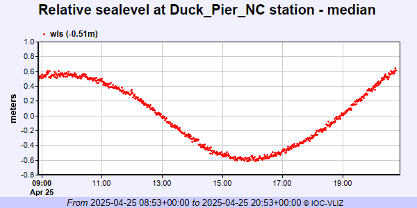 IOC Sea Level Station Monitoring Facility - realtime graph for 'dpnc2'  PSMSL Annual Mean Sea Level for '1636' 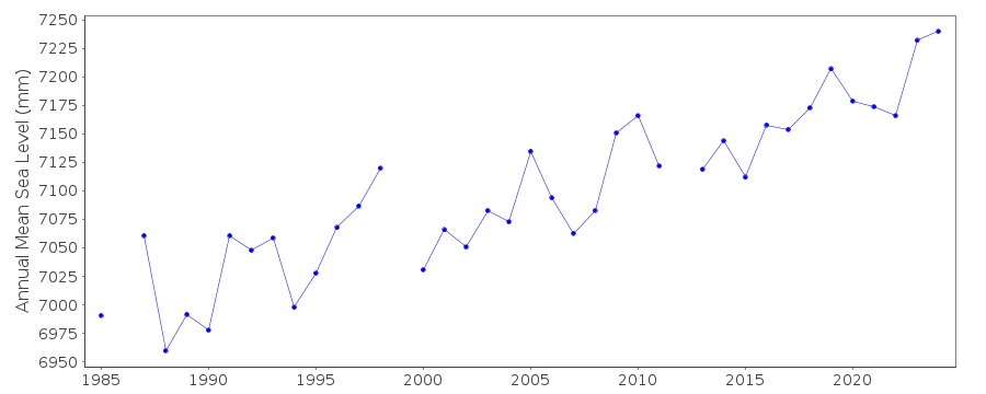 PSMSL Monthly Mean Sea Level for '1636' 
|
|
|