 |
SEALEVEL STATION CATALOG (SSC) |
|
|
|
|
|
| Station catalog metadata [edit] | [station overview] |
|---|
| SSC ID | SSC-corf | | Station Name | Corfu (Kerkyra) | | Country | Greece | | Latitude | 39.6282 | | Longitude | 19.905317 | | DateLastModified | 2015-10-22 19:02:29 |
| Distributed metadata source: IOC Sea Level Station Monitoring Facility corf |
|---|
| GTS station code | GR-CORF-00 |
| Status | Incorrect data |
| Local Contact | National Observatory of Athens ( Greece ) |
| Connection | BGAN |
| Country | Greece |
| Sensor 1 | |
| Type of sensor | rad |
| Sampling rate (min) | 1 |
| Sensor 2 | |
| Type of sensor | bat |
| Sampling rate (min) | 1 |
| Distributed metadata source: PSMSL |
| Name | CORFU ( KERKYRA ) |
| SONEL id | 2582 |
| Is RLR | Y |
| Has RLR Diagram | Y link |
| QC Flag | N |
| Old ID | 290/103 |
| Last Updated | 2026-03-13 |
| Supplier | HELLENIC NAVY HYDROGRAPHIC SERVICE |
| Address | Hellenic Navy Hydrographic Service, Geographic Policy and International Relations Office, TGN 1040, Athens, GREECE |
| Metric Start | 2004 |
| Metric End | 2025 |
| Metric Completeness | 86.7 |
| RLR Start | 2004 |
| RLR End | 2025 |
| RLR Completeness | 86.7 |
| Download metric sea level data. | Use only with extreme caution. |
IOC Sea Level Station Monitoring Facility - realtime graph for 'corf' 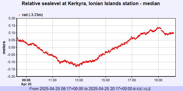 PSMSL Annual Mean Sea Level for '1933' 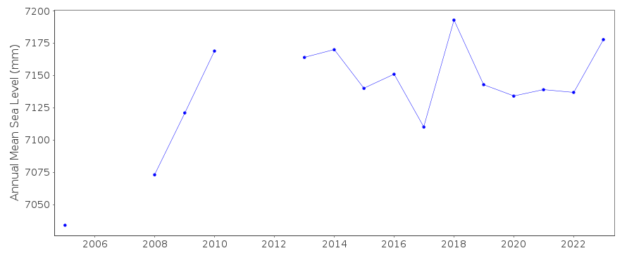 PSMSL Monthly Mean Sea Level for '1933' 
|
|
|