 |
SEALEVEL STATION CATALOG (SSC) |
|
|
|
|
|
| Station catalog metadata [edit] | [station overview] |
|---|
| SSC ID | SSC-ciuda | | Station Name | Ciudad Madero | | Country | Mexico | | Latitude | 22.25 | | Longitude | -97.8 | | DateLastModified | 2015-10-22 19:02:29 |
| Distributed metadata source: UHSLC |
| UHSLC id | 277 |
| SSC id | ciuda |
| UHSLC geojson | https://uhslc.soest.hawaii.edu/data/meta.geojson |
| Research quality data version a | 2004-03-24 - 2007-11-19 |
| RQ basin | atlantic |
| Distributed metadata source: PSMSL |
| Name | CIUDAD MADERO |
| UHSLC ID | 277 |
| SONEL id | 2052 |
| Is RLR | Y |
| Has RLR Diagram | Y link |
| QC Flag | N |
| Old ID | 920/066 |
| Last Updated | 1990-10-09 |
| Supplier | SERVICIO MAREOGRAFICO NACIONAL, MEXICO |
| Address | Servicio Mareografico Nacional, Instituto de Geofisica, Ciudad Universitaria, Delegacion de Coyoacan, 04510 Mexico D.F., MEXICO |
| Metric Start | 1962 |
| Metric End | 1979 |
| Metric Completeness | 96.8 |
| RLR Start | 1962 |
| RLR End | 1979 |
| RLR Completeness | 96.8 |
| Download metric sea level data. | Use only with extreme caution. |
| Name | TAMPICO (MUELLE FISCAL) |
| UHSLC ID | 277 |
| SONEL id | 2052 |
| Is RLR | N |
| Has RLR Diagram | N link |
| QC Flag | N |
| Old ID | 920/061 |
| Last Updated | null |
| Supplier | SERVICIO MAREOGRAFICO NACIONAL, MEXICO |
| Address | Servicio Mareografico Nacional, Instituto de Geofisica, Ciudad Universitaria, Delegacion de Coyoacan, 04510 Mexico D.F., MEXICO |
| Metric Start | 1952 |
| Metric End | 1966 |
| Metric Completeness | 98.3 |
| Download metric sea level data. | Use only with extreme caution. |
PSMSL Annual Mean Sea Level for '1020' 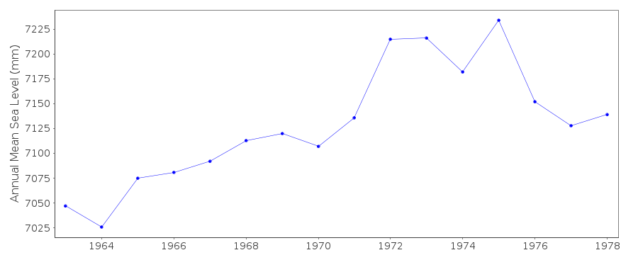 PSMSL Annual Mean Sea Level for '698'  PSMSL Monthly Mean Sea Level for '698' 
|
|
|