 |
SEALEVEL STATION CATALOG (SSC) |
|
|
|
|
|
| Station catalog metadata [edit] | [station overview] |
|---|
| SSC ID | SSC-chrs | | Station Name | Christmas Island | | Country | Australia | | Latitude | -10.4294 | | Longitude | 105.6693 | | DateLastModified | 2015-10-22 19:02:29 |
| Linked codes |
|---|
| Codes | Location | Latitude | Longitude | Sensors | IOC: chrs | Christmas_Island_AU | -10.4294 | 105.6693 | rad |
IOC: ffcj | Flying Fish Cove Jetty_Christmas_Is_AU | -10.4294 | 105.6694 | rad |
GLOSS: 47 | Christmas Is. | -10.41666 | 105.66666 | Float |
UHSLC: 170 | Christmas | -10.4167 | 105.6667 | N/A |
PTWC: chrs | Christmas_Island_AU | -10.4294 | 105.6693 | prs |
PSMSL: 1010 | CHRISTMAS ISLAND | -10.416667 | 105.666667 | N/A |
SONEL_GPS: 2929 | FLYING FISH COVE | -10.44997186 | 105.68849460 | N/A |
SONEL_TG: 2811 | FLYING FISH COVE | -10.42428600 | 105.67107800 | N/A |
| Distributed metadata source: IOC Sea Level Station Monitoring Facility chrs |
|---|
| GTS station code | 46290 |
| GTS message type | SZIO01 |
| Status | Operational |
| Local Contact | National Tidal Centre/Australian Bureau of Meteorology ( Australia ) |
| Connection | GTS message |
| Country | Australia |
| Sensor 1 | |
| Type of sensor | rad |
| Sampling rate (min) | 1 |
| Distributed metadata source: IOC Sea Level Station Monitoring Facility ffcj |
|---|
| GTS station code | 46291 |
| GTS message type | SZIO01 |
| Status | Operational |
| Local Contact | National Tidal Centre/Australian Bureau of Meteorology ( Australia ) |
| Connection | GTS message |
| Country | Australia |
| Sensor 1 | |
| Type of sensor | rad |
| Sampling rate (min) | 1 |
| Distributed metadata source: GLOSS Station Handbook |
|---|
| Time Zone | 105E, GMT + 7hrs | | Ocean | Indian | | Operational | No | | Responsible country | Australia | | Data acquisition rate | 15 minute samples | | Tide gauge benchmarks | CHS 1: circular brass plaque numbered CHS1 set in bedrock between the two cantilever loaders, Flying Fish Cove. | | Benchmark relationships | Tide Gauge Zero (TGZ) = 6.158m below CHS 1 (1986-1988) | | Auxiliary benchmarks | CHS 2: circular brass plaque numbered CHS 2 set in concrete pad at the root of the North Arm Cantilever jetty.
CHS 3: circular brass plaque numbered CHS 3 set on top of concrete pad support for South Arm Cantilever conveyor.
Rocky Point RM 3.
| | Other relevant information | Float/stilling well analogue gauge at this site 1966-1969.
Float/stilling well digital gauge at this site 1986-1988.
Geocentric measurements: Precise ephemeris, single point doppler fix (Rocky Point RM3) 1985.
| | Other relevant codes | NTF port No. 46290, UHSLC 170 | | Nearest Met. station | Rocky Point, Christmas Island |
| Distributed metadata source: PTWC COMP META file |
| DCP ID | 46290 |
| WMO | SZIO01 |
| Samp Rate | 1 |
| Num# Samp | 6 |
| Unit | M |
| Scale | 1.0000 |
| Xmt Int. | 003 |
| Fst Min. | 0000 |
| HAR | 1 |
| Owner | ABM |
| Distributed metadata source: UHSLC |
| UHSLC id | 170 |
| SSC id | chrs |
| GLOSS id | 47 |
| UHSLC geojson | https://uhslc.soest.hawaii.edu/data/meta.geojson |
| Research quality data version a | 1986-09-29 - 2021-12-31 |
| RQ basin | indian |
| Fast delivery | 1986-09-29 - 2026-05-31 |
| Distributed metadata source: PSMSL |
| Name | CHRISTMAS ISLAND |
| GLOSS id | 47 |
| UHSLC ID | 170 |
| SONEL id | 2929 |
| Is RLR | N |
| Has RLR Diagram | N link |
| QC Flag | N |
| Old ID | 563/001 |
| Last Updated | 2016-01-27 |
| Supplier | NATIONAL TIDAL CENTRE |
| Address | National Tidal Centre, Bureau of Meteorology, PO Box 421, Kent Town 5071, South Australia, AUSTRALIA |
| Metric Start | 1962 |
| Metric End | 2009 |
| Metric Completeness | 14.1 |
| Download metric sea level data. | Use only with extreme caution. |
IOC Sea Level Station Monitoring Facility - realtime graph for 'chrs' 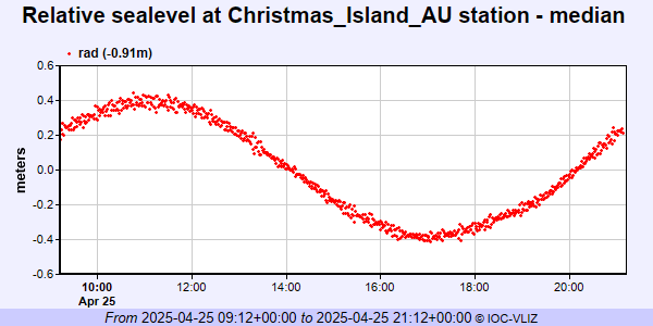 IOC Sea Level Station Monitoring Facility - realtime graph for 'ffcj' 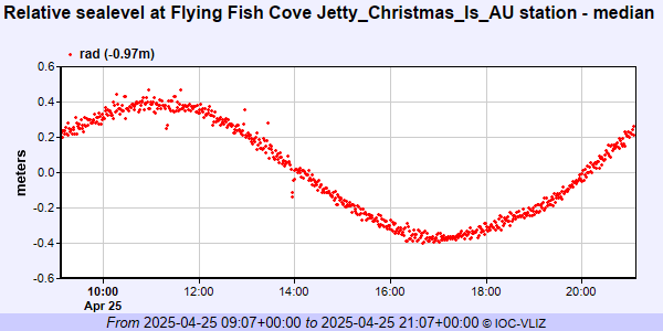 PSMSL Annual Mean Sea Level for '1010'  PSMSL Monthly Mean Sea Level for '1010' 
|
|
|