 |
SEALEVEL STATION CATALOG (SSC) |
|
|
|
|
|
| Station catalog metadata [edit] | [station overview] |
|---|
| SSC ID | SSC-ceut | | Station Name | Ceuta | | Country | Spain | | Latitude | 35.9 | | Longitude | -5.3166 | | DateLastModified | 2015-10-22 19:02:29 |
| Distributed metadata source: IOC Sea Level Station Monitoring Facility ceut |
|---|
| Status | Operational |
| Local Contact | Instituto Español de Oceanografía ( Spain ) |
| Connection | WEB service |
| Country | Spain |
| Sensor 1 | |
| Type of sensor | rad |
| Sampling rate (min) | 10 |
| Distributed metadata source: IOC Sea Level Station Monitoring Facility ceut1 |
|---|
| GTS station code | CEUT1 |
| GTS message type | SXXX33 |
| Status | Down |
| Local Contact | Joint Research Centre ( Europe ) |
| Other Contact | Instituto Geográfico Nacional ( Spain ) |
| Connection | BGAN |
| Country | Spain |
| Sensor 1 | |
| Type of sensor | rad |
| Sampling rate (min) | 1 |
| Distributed metadata source: IOC Sea Level Station Monitoring Facility ceut2 |
|---|
| Status | Operational |
| Local Contact | Joint Research Centre ( Europe ) |
| Other Contact | Instituto Geográfico Nacional ( Spain ) |
| Connection | WEB service |
| Country | Spain |
| Sensor 1 | |
| Type of sensor | rad |
| Sampling rate (min) | 0.1 |
| Distributed metadata source: GLOSS Station Handbook |
|---|
| Time Zone | 000E, GMT | | Ocean | Atlantic | | Operational | Yes | | Responsible country | Spain | | Additional parameters | Atmospheric pressure | | Tide gauge benchmarks | NRG-101 (Instituto Geografico Nacional) located in the stilling well mouth. Geometrical altitude: 3.401m; levelling: Ceuta-Tetuan line 1929 (1982).
TGZ (1996) = 4.195 metres under NGR-101
| | Benchmark relationships | SS.C.1 (IGN) located in the floor at the crowing of the west side of the Dock Espana in front of the window of the tide gauge place. Geometrical altitude: 2.666m; levelling: Ceuta-Tetuan line 1929 (1982).
SS.C.7 (IGN) located in the south of the dike cont | | Auxiliary benchmarks | SS.C.1
SS.C.7
| | Other relevant information | Two GPS campaigns. Project: SELF I (5 days, 24 hours a day in March 1993). SELF II (from 25-30 November 1996). | | Other relevant codes | UHSLC 207 | | Nearest Met. station | Observatorio de Ceuta |
| Distributed metadata source: UHSLC |
| UHSLC id | 207 |
| SSC id | ceut |
| GLOSS id | 249 |
| UHSLC geojson | https://uhslc.soest.hawaii.edu/data/meta.geojson |
| Research quality data version a | 1944-03-01 - 2017-12-31 |
| RQ basin | atlantic |
| Fast delivery | 1944-03-01 - 2024-09-24 |
| Distributed metadata source: PSMSL |
| Name | CEUTA-A |
| GLOSS id | 249 |
| UHSLC ID | 207 |
| Is RLR | N |
| Has RLR Diagram | N link |
| QC Flag | N |
| Old ID | 340/005 |
| Last Updated | 1993-11-25 |
| Supplier | INSTITUTO ESPAÑOL DE OCEANOGRAFIA |
| Address | Instituto Español de Oceanografía, Corazón de María, 8, 28002, Madrid, SPAIN |
| Metric Start | 1971 |
| Metric End | 1974 |
| Metric Completeness | 87.5 |
| Download metric sea level data. | Use only with extreme caution. |
| Name | CEUTA-B |
| GLOSS id | 249 |
| UHSLC ID | 207 |
| Is RLR | N |
| Has RLR Diagram | N link |
| QC Flag | N |
| Old ID | 340/006 |
| Last Updated | 1993-11-25 |
| Supplier | INSTITUTO ESPAÑOL DE OCEANOGRAFIA |
| Address | Instituto Español de Oceanografía, Corazón de María, 8, 28002, Madrid, SPAIN |
| Metric Start | 1975 |
| Metric End | 1977 |
| Metric Completeness | 86.1 |
| Download metric sea level data. | Use only with extreme caution. |
| Name | CEUTA-C |
| GLOSS id | 249 |
| UHSLC ID | 207 |
| Is RLR | N |
| Has RLR Diagram | N link |
| QC Flag | N |
| Old ID | 340/007 |
| Last Updated | 1993-11-25 |
| Supplier | INSTITUTO ESPAÑOL DE OCEANOGRAFIA |
| Address | Instituto Español de Oceanografía, Corazón de María, 8, 28002, Madrid, SPAIN |
| Metric Start | 1978 |
| Metric End | 1980 |
| Metric Completeness | 63.9 |
| Download metric sea level data. | Use only with extreme caution. |
| Name | CEUTA-D |
| GLOSS id | 249 |
| UHSLC ID | 207 |
| Is RLR | N |
| Has RLR Diagram | N link |
| QC Flag | N |
| Old ID | 340/008 |
| Last Updated | 1993-11-25 |
| Supplier | INSTITUTO ESPAÑOL DE OCEANOGRAFIA |
| Address | Instituto Español de Oceanografía, Corazón de María, 8, 28002, Madrid, SPAIN |
| Metric Start | 1980 |
| Metric End | 1990 |
| Metric Completeness | 86.4 |
| Download metric sea level data. | Use only with extreme caution. |
| Name | CEUTA |
| GLOSS id | 249 |
| UHSLC ID | 207 |
| SONEL id | 650 |
| Is RLR | Y |
| Has RLR Diagram | Y link |
| QC Flag | N |
| Old ID | 340/001 |
| Last Updated | 2019-03-05 |
| Supplier | INSTITUTO ESPAÑOL DE OCEANOGRAFIA |
| Address | Instituto Español de Oceanografía, Corazón de María, 8, 28002, Madrid, SPAIN |
| Metric Start | 1944 |
| Metric End | 2018 |
| Metric Completeness | 96.6 |
| RLR Start | 1944 |
| RLR End | 2018 |
| RLR Completeness | 96.6 |
| Download metric sea level data. | Use only with extreme caution. |
IOC Sea Level Station Monitoring Facility - realtime graph for 'ceut'  IOC Sea Level Station Monitoring Facility - realtime graph for 'ceut1'  IOC Sea Level Station Monitoring Facility - realtime graph for 'ceut2' 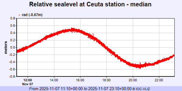 PSMSL Annual Mean Sea Level for '1316'  PSMSL Annual Mean Sea Level for '1416'  PSMSL Annual Mean Sea Level for '1485'  PSMSL Annual Mean Sea Level for '1517'  PSMSL Annual Mean Sea Level for '498' 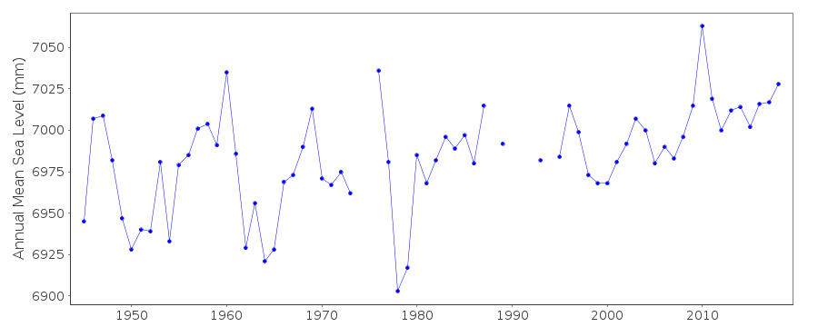 PSMSL Monthly Mean Sea Level for '498' 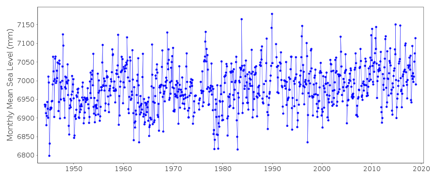
|
|
|