 |
SEALEVEL STATION CATALOG (SSC) |
|
|
|
|
|
| Station catalog metadata [edit] | [station overview] |
|---|
| SSC ID | SSC-cctx | | Station Name | Corpus Christi | | Country | United States | | Latitude | 27.58 | | Longitude | -97.2167 | | DateLastModified | 2015-10-22 19:02:29 |
| Linked codes |
|---|
| Codes | Location | Latitude | Longitude | Sensors | IOC: cctx | Corpus Christi, TX | 27.58 | -97.2167 | wls |
IOC: cctx2 | Corpus Christi, TX | 27.58 | -97.2167 | pwl |
UHSLC: 770 | Corpus Cristi | 27.58 | -97.2167 | N/A |
PTWC: cctx | Corpus_Christi_TX | 27.5808 | -97.2164 | pwc, pwl, bwl |
PSMSL: 1903 | CORPUS CHRISTI, GULF MEXICO, TX | 27.583333 | -97.216667 | N/A |
| Distributed metadata source: IOC Sea Level Station Monitoring Facility cctx |
|---|
| GTS station code | 336943DC |
| GTS message type | SXXX03 |
| Status | Down |
| Local Contact | National Ocean Service-NOAA ( USA ) |
| Connection | WEB service |
| Country | USA |
| Sensor 1 | |
| Type of sensor | wls |
| Sampling rate (min) | 1 |
| Distributed metadata source: IOC Sea Level Station Monitoring Facility cctx2 |
|---|
| GTS station code | 336943DC |
| GTS message type | SXXX03 |
| Status | Down |
| Local Contact | National Ocean Service-NOAA ( USA ) |
| Connection | GTS message |
| Country | USA |
| Sensor 1 | |
| Type of sensor | pwl |
| Sampling rate (min) | 1 |
| Distributed metadata source: PTWC COMP META file |
| DCP ID | 336943DC |
| WMO | SXXX03 |
| Samp Rate | 6 |
| Num# Samp | 1 |
| Unit | M |
| Scale | 1.3840 |
| Xmt Int. | 006 |
| Fst Min. | 0000 |
| HAR | 1 |
| Owner | NOS |
| Distributed metadata source: UHSLC |
| UHSLC id | 770 |
| SSC id | cctx |
| UHSLC geojson | https://uhslc.soest.hawaii.edu/data/meta.geojson |
| Research quality data version a | 1983-12-01 - 2021-12-31 |
| RQ basin | atlantic |
| Distributed metadata source: PSMSL |
| Name | CORPUS CHRISTI, GULF MEXICO, TX |
| UHSLC ID | 770 |
| Is RLR | Y |
| Has RLR Diagram | Y link |
| QC Flag | N |
| Old ID | 940/015 |
| Last Updated | 2022-02-10 |
| Supplier | N.O.A.A. / N.O.S. |
| Address | N.O.A.A. / N.O.S., N/oes33, Ssmc4, Room 6531, 1305 East-West Highway, Silver Spring, , MD 20910, UNITED STATES |
| Metric Start | 1998 |
| Metric End | 2021 |
| Metric Completeness | 99.7 |
| RLR Start | 1998 |
| RLR End | 2021 |
| RLR Completeness | 99.7 |
| Download metric sea level data. | Use only with extreme caution. |
IOC Sea Level Station Monitoring Facility - realtime graph for 'cctx'  IOC Sea Level Station Monitoring Facility - realtime graph for 'cctx2'  PSMSL Annual Mean Sea Level for '1903' 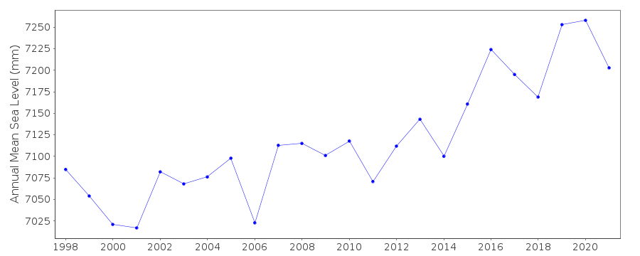 PSMSL Monthly Mean Sea Level for '1903' 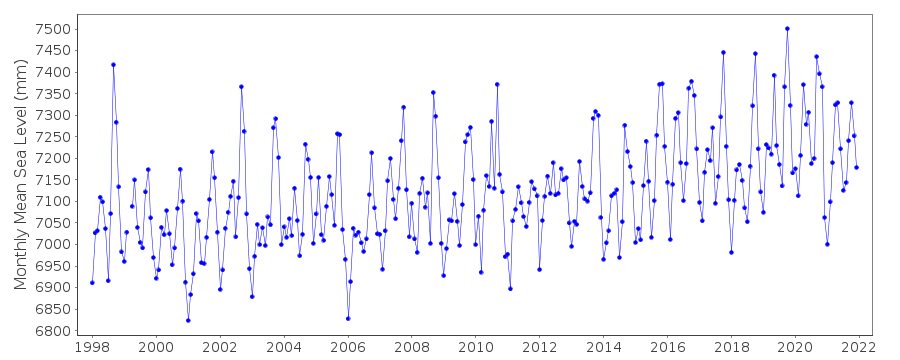
|
|
|