 |
SEALEVEL STATION CATALOG (SSC) |
|
|
|
|
|
| Station catalog metadata [edit] | [station overview] |
|---|
| SSC ID | SSC-casc | | Station Name | Cascais | | Country | Portugal | | Latitude | 38.693158 | | Longitude | -9.415384 | | DateLastModified | 2015-10-22 19:02:29 |
| Distributed metadata source: IOC Sea Level Station Monitoring Facility casc |
|---|
| Status | Operational |
| Local Contact | Direção-Geral do Território ( Portugal ) |
| Connection | SOCKET |
| Country | Portugal |
| Sensor 1 | |
| Type of sensor | rad |
| Sampling rate (min) | 0.0833 |
| Distributed metadata source: GLOSS Station Handbook |
|---|
| Time Zone | 000E, GMT | | Ocean | Atlantic | | Operational | Yes | | Responsible country | Portugal | | Tide gauge benchmarks | m3 - benchmark bolt at the root of the groin where the tide gauge is located
NP1 - benchmark bolt at the entrance of the cidadela de Cascais
| | Benchmark relationships | Tide gauge zero (TGZ) = Portuguese Hydrographic Institute Chart Datum
TGZ = 7.277m below m3
TGZ = 15.437m below NP1
| | Auxiliary benchmarks | m1 is 6.237m above Chart Datum
m2 is 6.233m above Chart Datum
m4 is 11.454m above Chart Datum
m5 is 6.597m above Chart Datum
| | Other relevant codes | UHSLC 209 |
| Distributed metadata source: UHSLC |
| UHSLC id | 209 |
| SSC id | casc |
| GLOSS id | 246 |
| UHSLC geojson | https://uhslc.soest.hawaii.edu/data/meta.geojson |
| Research quality data version a | 1959-01-01 - 2005-12-31 |
| RQ basin | atlantic |
| Fast delivery | 1959-01-01 - 2026-05-31 |
| Distributed metadata source: PSMSL |
| Name | CASCAIS A |
| GLOSS id | 246 |
| UHSLC ID | 209 |
| Is RLR | N |
| Has RLR Diagram | N link |
| QC Flag | N |
| Old ID | 210/022 |
| Last Updated | 2014-01-28 |
| Supplier | UNIVERSITY OF HAWAII SEA LEVEL CENTER |
| Address | University of Hawaii Sea Level Center, Department of Oceanography Division of Natural Sciences, 1000 Pope Road, Honolulu, Hawaii 96822, UNITED STATES |
| Metric Start | 1959 |
| Metric End | 2005 |
| Metric Completeness | 89.2 |
| Download metric sea level data. | Use only with extreme caution. |
| Name | CASCAIS |
| GLOSS id | 246 |
| UHSLC ID | 209 |
| SONEL id | 648 |
| Is RLR | Y |
| Has RLR Diagram | Y link |
| QC Flag | N |
| Old ID | 210/021 |
| Last Updated | 2016-01-27 |
| Supplier | INSTITUTO PORT. DE CARTOGRAFIA E CADASTRO |
| Address | Instituto Port. de Cartografia e Cadastro, Rua de Artilharia Um, No. 107, P - 1070 Lisboa, PORTUGAL |
| Metric Start | 1882 |
| Metric End | 1993 |
| Metric Completeness | 92.6 |
| RLR Start | 1882 |
| RLR End | 1993 |
| RLR Completeness | 92.6 |
| Download metric sea level data. | Use only with extreme caution. |
IOC Sea Level Station Monitoring Facility - realtime graph for 'casc' 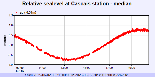 PSMSL Annual Mean Sea Level for '2201'  PSMSL Annual Mean Sea Level for '52' 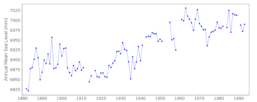 PSMSL Monthly Mean Sea Level for '52' 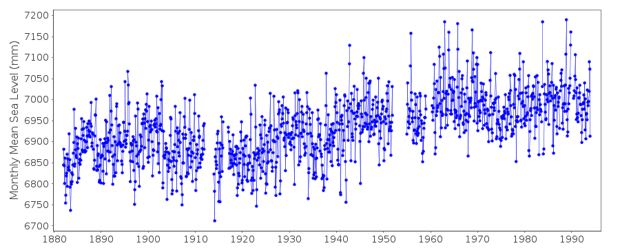
|
|
|