 |
SEALEVEL STATION CATALOG (SSC) |
|
|
|
|
|
| Station catalog metadata [edit] | [station overview] |
|---|
| SSC ID | SSC-carn | | Station Name | Carnarvon | | Country | Australia | | Latitude | -24.9 | | Longitude | 113.65 | | DateLastModified | 2015-10-22 19:02:29 |
| Distributed metadata source: GLOSS Station Handbook |
|---|
| Time Zone | 120E, GMT + 8hrs | | Ocean | Indian | | Operational | Yes | | Responsible country | Australia | | Data acquisition rate | 5 minute samples | | Additional parameters | None | | Tide gauge benchmarks | Peg 13, the top of a section of rail set in concrete between locomotive rails about 10 metres east of the abutment of Main Jetty. | | Benchmark relationships | Tide Gauge Zero (TGZ) = 4.892m below TGBM
TGZ = 0.814m below Australian Height Datum (AHD)
| | Auxiliary benchmarks | A100: PWD bronze plaque in concrete in the vicinity of the boat harbour.
A876: PWD bronze plaque set in concrete deck of the boat harbour jetty beside the tide gauge.
A881: PWD bronze plaque set in concrete deck of the boat harbour jetty.
A882: PWD bronze plaque set in concrete deck of boat harbour jetty head.
CVN14: bolt in concrete block beside PWD Office, Carnarvon
| | Other relevant information | Float/stilling well analogue gauge operated at Main Jetty 1964-1977.
Float/stilling/well analogue gauge operated in present location in the boat harbour 1977-1989.
Geo. measurement: Precise ephemeris, doppler fix, Brown Range GC18A,1982
PSMSL also hold data from another gauge in Carnarvon (PSMSL Code 680/480 1966-1976, 1978-1982, 1984).
| | Other relevant codes | NTF port no. 62370, UHSLC 167 | | Nearest Met. station | Carnarvon Airport |
| Distributed metadata source: UHSLC |
| UHSLC id | 167 |
| SSC id | carn |
| GLOSS id | 52 |
| UHSLC geojson | https://uhslc.soest.hawaii.edu/data/meta.geojson |
| Research quality data version a | 1984-04-07 - 2021-12-31 |
| RQ basin | indian |
| Fast delivery | 1984-04-07 - 2021-12-31 |
| Distributed metadata source: PSMSL |
| Name | CARNARVON |
| GLOSS id | 52 |
| UHSLC ID | 167 |
| Is RLR | Y |
| Has RLR Diagram | Y link |
| QC Flag | N |
| Old ID | 680/479 |
| Last Updated | 2026-06-01 |
| Supplier | NATIONAL TIDAL CENTRE |
| Address | National Tidal Centre, Bureau of Meteorology, PO Box 421, Kent Town 5071, South Australia, AUSTRALIA |
| Metric Start | 1965 |
| Metric End | 2024 |
| Metric Completeness | 84.3 |
| RLR Start | 1965 |
| RLR End | 2024 |
| RLR Completeness | 84.3 |
| Download metric sea level data. | Use only with extreme caution. |
| Name | CARNARVON II |
| GLOSS id | 52 |
| UHSLC ID | 167 |
| Is RLR | N |
| Has RLR Diagram | N link |
| QC Flag | N |
| Old ID | 680/480 |
| Last Updated | 1993-05-27 |
| Supplier | NATIONAL TIDAL FACILITY |
| Address | National Tidal Facility, G.P.O. Box 2100, S.A. 5001, Adelaide , AUSTRALIA |
| Metric Start | 1965 |
| Metric End | 1989 |
| Metric Completeness | 65.7 |
| Download metric sea level data. | Use only with extreme caution. |
PSMSL Annual Mean Sea Level for '1115' 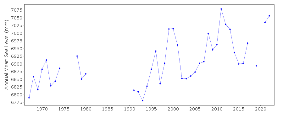 PSMSL Annual Mean Sea Level for '1126'  PSMSL Monthly Mean Sea Level for '1126' 
|
|
|