 |
SEALEVEL STATION CATALOG (SSC) |
|
|
|
|
|
| Station catalog metadata [edit] | [station overview] |
|---|
| SSC ID | SSC-cana | | Station Name | Cananeia | | Country | Brazil | | Latitude | -25.01666 | | Longitude | -47.93333 | | DateLastModified | 2015-10-22 19:02:29 |
| Distributed metadata source: GLOSS Station Handbook |
|---|
| Time Zone | 045W, GMT - 3hrs | | Ocean | Atlantic | | Operational | Yes | | Responsible country | Brazil | | Additional parameters | Meteorological, CGPS, Gravimetry | | Tide gauge benchmarks | Zero of the gauge is 4.143m below the RN level. Levelled Sept. 1999 | | Other relevant information | Mean sea level, based on 1978 data, is 1.662m above the zero of the gauge.
For additional information see 'Tides and tide gauges of Cananeia and Ubatuba-Brazil (lat.24o)' by A.R. Mosquita and J. Harari, Relat. Inst. Oceanogr. Univ. S. Paulo, S. Paulo, no. 11, pp. 1-14, 1983.
http://www.io.usp.br/english/auxiliary.html | | Other relevant codes | UHSLC 281 | | Nearest Met. station | Near the tidal station |
| Distributed metadata source: UHSLC |
| UHSLC id | 281 |
| SSC id | cana |
| GLOSS id | 194 |
| UHSLC geojson | https://uhslc.soest.hawaii.edu/data/meta.geojson |
| Research quality data version a | 1954-02-26 - 2006-12-31 |
| Research quality data version b | 2014-01-29 - 2016-10-29 |
| RQ basin | atlantic |
| Distributed metadata source: PSMSL |
| Name | CANANEIA |
| GLOSS id | 194 |
| UHSLC ID | 281 |
| SONEL id | 752 |
| Is RLR | Y |
| Has RLR Diagram | Y link |
| QC Flag | Y |
| Old ID | 874/051 |
| Last Updated | 2007-07-18 |
| Supplier | INSTITUTO OCEANOGRAFICO, U.S.P. |
| Address | Instituto Oceanografico, Universidade de Sao Paulo, Cidade Universitaria, Butanta, Cep 05508, Sao Paulo, BRAZIL |
| Metric Start | 1954 |
| Metric End | 2006 |
| Metric Completeness | 96.7 |
| RLR Start | 1954 |
| RLR End | 2006 |
| RLR Completeness | 96.7 |
| Download metric sea level data. | Use only with extreme caution. |
PSMSL Annual Mean Sea Level for '726'  PSMSL Monthly Mean Sea Level for '726' 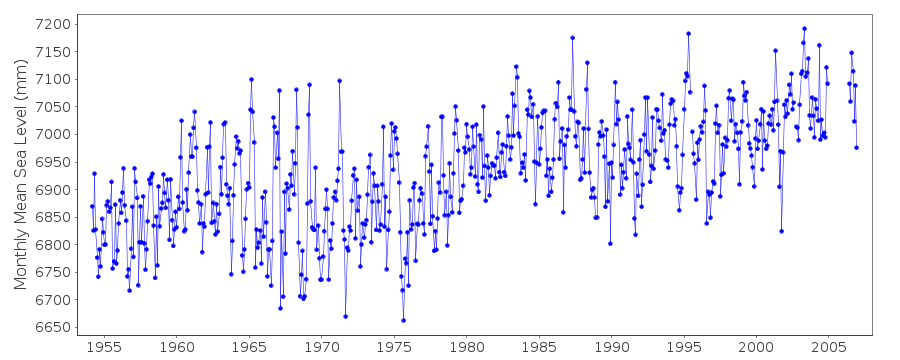
|
|
|