 |
SEALEVEL STATION CATALOG (SSC) |
|
|
|
|
|
| Station catalog metadata [edit] | [station overview] |
|---|
| SSC ID | SSC-cabos | | Station Name | Cabo San Antonio | | Country | Cuba | | Latitude | 21.9 | | Longitude | -84.9 | | DateLastModified | 2015-10-22 19:02:29 |
| Linked codes |
|---|
| Codes | Location | Latitude | Longitude | Sensors | GLOSS: 214 | Cabo San Antonio | 21.9 | -84.9 | Float |
PSMSL: 1297 | CABO DE SAN ANTONIO | 21.9 | -84.9 | N/A |
SONEL_TG: 2874 | CABO SAN ANTONIO | 21.90067100 | -84.90724900 | N/A |
| Distributed metadata source: GLOSS Station Handbook |
|---|
| Time Zone | 075W, GMT - 5hrs | | Ocean | Atlantic | | Operational | Yes | | Responsible country | Cuba |
| Distributed metadata source: PSMSL |
| Name | CABO DE SAN ANTONIO |
| GLOSS id | 214 |
| Is RLR | Y |
| Has RLR Diagram | Y link |
| QC Flag | N |
| Old ID | 930/071 |
| Last Updated | 2025-07-18 |
| Supplier | CUBAN NATIONAL TIDAL SERVICE |
| Address | Cuban National Tidal Service, Calle 4 No. 304, E/3 Y 3-a, Playa, Cuidad Habana, CUBA |
| Metric Start | 1971 |
| Metric End | 2024 |
| Metric Completeness | 83.6 |
| RLR Start | 1971 |
| RLR End | 2024 |
| RLR Completeness | 83.6 |
| Download metric sea level data. | Use only with extreme caution. |
PSMSL Annual Mean Sea Level for '1297'  PSMSL Monthly Mean Sea Level for '1297' 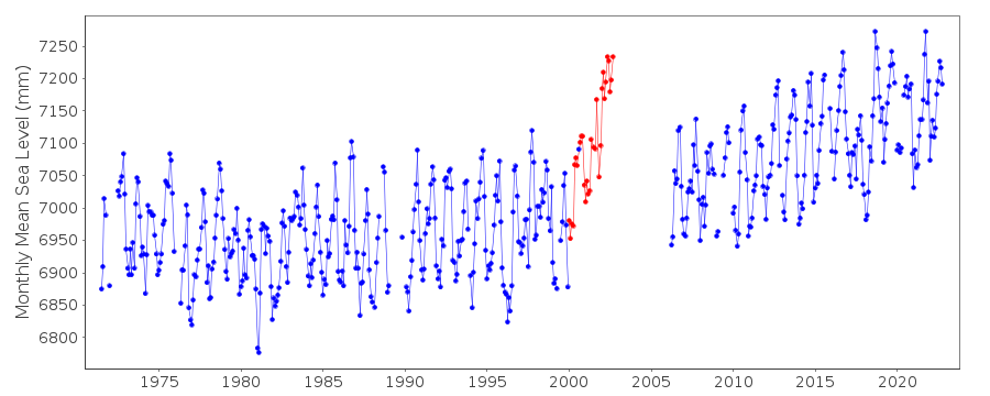
|
|
|