 |
SEALEVEL STATION CATALOG (SSC) |
|
|
|
|
|
| Station catalog metadata [edit] | [station overview] |
|---|
| SSC ID | SSC-burn | | Station Name | Burnett Heads | | Country | Australia | | Latitude | -24.76666 | | Longitude | 152.38 | | DateLastModified | 2025-05-08 22:03:16 |
| Distributed metadata source: GLOSS Station Handbook |
|---|
| Time Zone | 150E, GMT + 10hrs | | Ocean | Pacific | | Operational | Yes | | Responsible country | Australia | | Data acquisition rate | 10 minute recording interval | | Tide gauge benchmarks | PSM 3853 Brass plug set in concrete kerb of the southern approach to the Bulk Sugar Wharf, Port Bundaberg | | Benchmark relationships | Tide Gauge Zero (TGZ) = 5.721m below TGBM
TGZ = 1.352m below Australian Height Datum (AHD)
TGZ = 6.061m below TGBM down from 1/1/94
TGZ = 1.693m below AHD
| | Auxiliary benchmarks | PSM 4504 Standard type brass plaque set in a concrete block beside pipes running from the Oil Terminal to the Oil Berth.
PSM 4503 Standard type brass plaque set in a concrete block at the corner of Buss and Powers Streets.
PSM 36119 Standard type brass plaque set in a concrete block inside the Bundaberg Molasses Terminal enclosure.
| | Other relevant information | Float/stilling well gauges, different locations on same wharf 1960-1976.
Float/stilling/well gauge on Tug Berth 1976-1979.
Queensland Beach Protection Authority operate analogue and digital recorders at Burnett Heads 2.5km away.
Geocentric measurement: Precise ephemeris, single point doppler fix PSM 43534 in 1981 approximately 6km from gauge.
| | Other relevant codes | NTF port no. 59820, UHSLC 332 | | Nearest Met. station | Bundaberg Post Office |
| Distributed metadata source: UHSLC |
| UHSLC id | 332 |
| SSC id | burn |
| GLOSS id | 59 |
| UHSLC geojson | https://uhslc.soest.hawaii.edu/data/meta.geojson |
| Research quality data version a | 1984-01-01 - 2021-12-31 |
| RQ basin | pacific |
| Fast delivery | 1984-01-01 - 2026-05-31 |
| Distributed metadata source: PSMSL |
| Name | BUNDABERG, BURNETT HEADS |
| GLOSS id | 59 |
| UHSLC ID | 332 |
| SONEL id | 2927 |
| Is RLR | Y |
| Has RLR Diagram | Y link |
| QC Flag | N |
| Old ID | 680/073 |
| Last Updated | 2025-03-20 |
| Supplier | NATIONAL TIDAL CENTRE |
| Address | National Tidal Centre, Bureau of Meteorology, PO Box 421, Kent Town 5071, South Australia, AUSTRALIA |
| Metric Start | 1966 |
| Metric End | 2025 |
| Metric Completeness | 96.7 |
| RLR Start | 1966 |
| RLR End | 2025 |
| RLR Completeness | 96.7 |
| Download metric sea level data. | Use only with extreme caution. |
| Name | BUNDABERG II |
| GLOSS id | 59 |
| UHSLC ID | 332 |
| Is RLR | N |
| Has RLR Diagram | N link |
| QC Flag | N |
| Old ID | 680/074 |
| Last Updated | 1993-05-24 |
| Supplier | NATIONAL TIDAL FACILITY |
| Address | National Tidal Facility, G.P.O. Box 2100, S.A. 5001, Adelaide , AUSTRALIA |
| Metric Start | 1966 |
| Metric End | 1990 |
| Metric Completeness | 95.3 |
| Download metric sea level data. | Use only with extreme caution. |
PSMSL Annual Mean Sea Level for '1154' 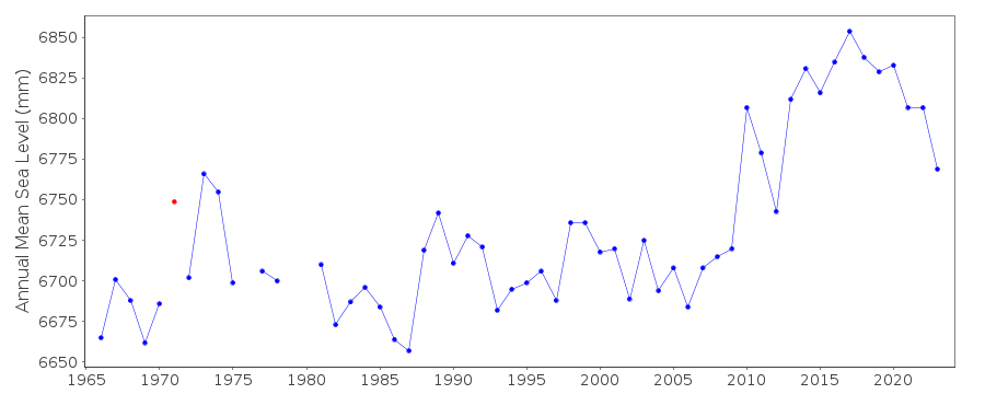 PSMSL Annual Mean Sea Level for '1166'  PSMSL Monthly Mean Sea Level for '1166' 
|
|
|