 |
SEALEVEL STATION CATALOG (SSC) |
|
|
|
|
|
| Station catalog metadata [edit] | [station overview] |
|---|
| SSC ID | SSC-buko | | Station Name | Bukom | | Country | Singapore | | Latitude | 1.225643 | | Longitude | 103.778463 | | DateLastModified | 2015-10-22 19:02:29 |
| Linked codes |
|---|
| Codes | Location | Latitude | Longitude | Sensors | PSMSL: 1895 | WEST COAST | 1.3 | 103.766667 | N/A |
PSMSL: 2032 | BUKOM | 1.225643 | 103.778463 | N/A |
| Distributed metadata source: PSMSL |
| Name | WEST COAST |
| UHSLC ID | 327 |
| Is RLR | Y |
| Has RLR Diagram | Y link |
| QC Flag | N |
| Old ID | 555/081 |
| Last Updated | 2023-04-24 |
| Supplier | MARITIME PORT AUTHORITY OF SINGAPORE |
| Address | Maritime Port Authority of Singapore, Hydrographic Department, 460 Alexandra Road, PSA Building, #20-00 Singapore 119963, SINGAPORE |
| Metric Start | 1997 |
| Metric End | 2022 |
| Metric Completeness | 98.7 |
| RLR Start | 1997 |
| RLR End | 2022 |
| RLR Completeness | 98.7 |
| Download metric sea level data. | Use only with extreme caution. |
| Name | BUKOM |
| UHSLC ID | 327 |
| Is RLR | Y |
| Has RLR Diagram | Y link |
| QC Flag | N |
| Old ID | 555/010 |
| Last Updated | 2023-04-24 |
| Supplier | MARITIME PORT AUTHORITY OF SINGAPORE |
| Address | Maritime Port Authority of Singapore, Hydrographic Department, 460 Alexandra Road, PSA Building, #20-00 Singapore 119963, SINGAPORE |
| Metric Start | 2008 |
| Metric End | 2022 |
| Metric Completeness | 100.0 |
| RLR Start | 2008 |
| RLR End | 2022 |
| RLR Completeness | 100.0 |
| Download metric sea level data. | Use only with extreme caution. |
PSMSL Annual Mean Sea Level for '1895' 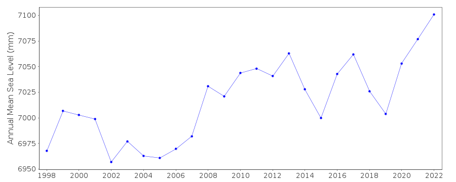 PSMSL Annual Mean Sea Level for '2032' 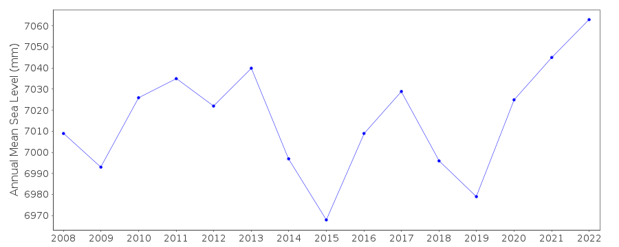 PSMSL Monthly Mean Sea Level for '2032' 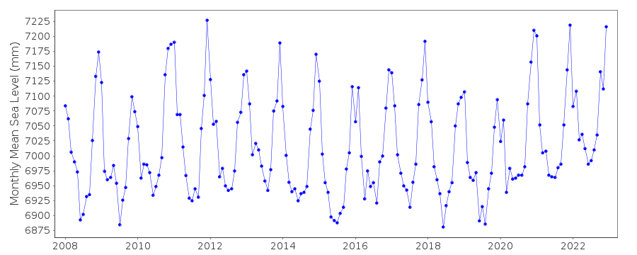
|
|
|