 |
SEALEVEL STATION CATALOG (SSC) |
|
|
|
|
|
| Station catalog metadata [edit] | [station overview] |
|---|
| SSC ID | SSC-brom | | Station Name | Broome | | Country | Australia | | Latitude | -18.0008 | | Longitude | 122.2186 | | DateLastModified | 2015-10-22 19:02:29 |
| Distributed metadata source: IOC Sea Level Station Monitoring Facility brom |
|---|
| GTS station code | 62650 |
| GTS message type | SZAU01 |
| Status | Operational |
| Local Contact | National Tidal Centre/Australian Bureau of Meteorology ( Australia ) |
| Connection | GTS message |
| Country | Australia |
| Sensor 1 | |
| Type of sensor | aqu |
| Sampling rate (min) | 1 |
| Distributed metadata source: GLOSS Station Handbook |
|---|
| Time Zone | 120E, GMT + 8hrs | | Ocean | Indian | | Operational | Yes | | Responsible country | Australia | | Data acquisition rate | 6 minute interval | | Additional parameters | barometric pressure, water/air temperature, wind speed & direction | | Tide gauge benchmarks | A P.W.D. bronze plaque stamped 'TIDAL BM' set in concrete deck of jetty above the northern end of the boat landing. | | Benchmark relationships | Tide Gauge Zero (TGZ) = 12.537m below TGBM.
TGZ = 4.462m below Australian Height Datum (AHD).
| | Auxiliary benchmarks | Admiralty BM cut in face of large rock on south side of root of jetty.
EP 2 - A bolt set in concrete deck beside the telephone box on the southern end of the Transit Shed, Broome jetty.
B712 - A standard brass plaque set in concrete approx. 250m south of the root of the jetty.
Station Hill - a brass plaque trig. Station located 9km north of TGBM.
Broome 184 - Coastal Array Primary benchmark = 12.794m AHD
Tide Broome - SEAFRAME Sensor BM = 8.296m AHD
C/84 - Datum for AHD heights = 8.565m AHD
Broome 183 = 14.140m AHD
Broome 185 = 14.093m AHD
| | Other relevant information | Float/stilling well analogue gauge operated at this location 1965-1982.
Geocentric measurements: Precise ephemeris, single point doppler fix 1985: multistation GPS 1986, (Station Hill).
PSMSL also hold data from another gauge at Broome (PSMSL Code 680/498, 1966-1983).
| | Other relevant codes | NTF port no. 62650, UHSLC 166 | | Nearest Met. station | Broome Airport |
| Distributed metadata source: PTWC COMP META file |
| DCP ID | 62650 |
| WMO | SZAU01 |
| Samp Rate | 1 |
| Num# Samp | 6 |
| Unit | M |
| Scale | 1.0000 |
| Xmt Int. | 003 |
| Fst Min. | 0000 |
| HAR | 1 |
| Owner | ABM |
| Distributed metadata source: UHSLC |
| UHSLC id | 166 |
| SSC id | brom |
| GLOSS id | 40 |
| UHSLC geojson | https://uhslc.soest.hawaii.edu/data/meta.geojson |
| Research quality data version a | 1986-07-12 - 2021-12-31 |
| RQ basin | indian |
| Fast delivery | 1986-07-12 - 2026-05-31 |
| Distributed metadata source: PSMSL |
| Name | BROOME |
| GLOSS id | 40 |
| UHSLC ID | 166 |
| SONEL id | 3221 |
| Is RLR | Y |
| Has RLR Diagram | Y link |
| QC Flag | N |
| Old ID | 680/497 |
| Last Updated | 2025-03-20 |
| Supplier | NATIONAL TIDAL CENTRE |
| Address | National Tidal Centre, Bureau of Meteorology, PO Box 421, Kent Town 5071, South Australia, AUSTRALIA |
| Metric Start | 1966 |
| Metric End | 2025 |
| Metric Completeness | 85.8 |
| RLR Start | 1992 |
| RLR End | 2025 |
| RLR Completeness | 97.3 |
| Download metric sea level data. | Use only with extreme caution. |
| Name | BROOME II |
| GLOSS id | 40 |
| UHSLC ID | 166 |
| Is RLR | N |
| Has RLR Diagram | N link |
| QC Flag | N |
| Old ID | 680/498 |
| Last Updated | 1993-05-24 |
| Supplier | NATIONAL TIDAL FACILITY |
| Address | National Tidal Facility, G.P.O. Box 2100, S.A. 5001, Adelaide , AUSTRALIA |
| Metric Start | 1966 |
| Metric End | 1989 |
| Metric Completeness | 74.0 |
| Download metric sea level data. | Use only with extreme caution. |
IOC Sea Level Station Monitoring Facility - realtime graph for 'brom' 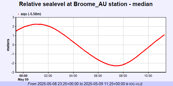 PSMSL Annual Mean Sea Level for '1159' 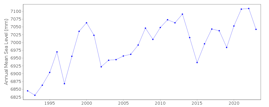 PSMSL Annual Mean Sea Level for '1171'  PSMSL Monthly Mean Sea Level for '1171' 
|
|
|