 |
SEALEVEL STATION CATALOG (SSC) |
|
|
|
|
|
| Station catalog metadata [edit] | [station overview] |
|---|
| SSC ID | SSC-boob | | Station Name | Booby Island | | Country | Australia | | Latitude | -10.6 | | Longitude | 141.91666 | | DateLastModified | 2015-10-22 19:02:29 |
| Linked codes |
|---|
| Codes | Location | Latitude | Longitude | Sensors | GLOSS: 61 | Booby Is. | -10.6 | 141.91666 | Float, Bubbler |
UHSLC: 336 | Booby Island | -10.6033 | 141.91 | N/A |
PSMSL: 1268 | BOOBY ISLAND | -10.60255 | 141.910133 | N/A |
PSMSL: 1333 | BOOBY ISLAND II | -10.6 | 141.9 | N/A |
SONEL_TG: 2817 | BOOBY ISLAND | -10.60300000 | 141.91000000 | N/A |
| Distributed metadata source: GLOSS Station Handbook |
|---|
| Time Zone | 150E, GMT + 10 hrs | | Ocean | Indian | | Operational | Yes | | Responsible country | Australia | | Data acquisition rate | 6 minute interval | | Tide gauge benchmarks | NMV/B/458: RAN BM 'A' The top of an iron stake driven into the rock and standing about 0.23m high on the north west side of Booby Island approximately 6m north of the tide gauge hut. | | Benchmark relationships | Tide Gauge Zero (TGZ) = 10.97m below TGBM.
TGZ = 2.68m below Australian Height Datum (AHD) - trig. heighting.
| | Auxiliary benchmarks | NMV/B/459: RAN BM 'B' The eastern bolt of 2 stainless steel bolts holding a clamp on the tide gauge pipe, approx. at high water and immediately in front of and to the north of a cement slab through which the pipe runs.
NMV/B/461: 'Charlie 72' An AHS bronze plaque to the west of NMV/B/459.
| | Other relevant information | Data is e-mailed to NTF on a daily basis.
MACE electronic solid state recording system installed May 1991, replacing the previous electromechanical recording/transmitting system.
Note: Booby Island Lighthouse (nearest meteorological station) only measures rainfall data.
PSMSL also hold data from another gauge at Booby Island (PSMSL Code 680/024, 1970-1980). | | Other relevant codes | NTF port no. 58230, UHSLC 336 | | Nearest Met. station | Booby Island Lighthouse |
| Distributed metadata source: UHSLC |
| UHSLC id | 336 |
| SSC id | boob |
| GLOSS id | 61 |
| UHSLC geojson | https://uhslc.soest.hawaii.edu/data/meta.geojson |
| Research quality data version a | 1988-01-01 - 2021-12-31 |
| RQ basin | pacific |
| Fast delivery | 1988-01-01 - 2026-05-31 |
| Distributed metadata source: PSMSL |
| Name | BOOBY ISLAND |
| GLOSS id | 61 |
| UHSLC ID | 336 |
| Is RLR | Y |
| Has RLR Diagram | Y link |
| QC Flag | N |
| Old ID | 680/025 |
| Last Updated | 2026-06-01 |
| Supplier | NATIONAL TIDAL CENTRE |
| Address | National Tidal Centre, Bureau of Meteorology, PO Box 421, Kent Town 5071, South Australia, AUSTRALIA |
| Metric Start | 1970 |
| Metric End | 2025 |
| Metric Completeness | 74.4 |
| RLR Start | 1970 |
| RLR End | 2025 |
| RLR Completeness | 74.4 |
| Download metric sea level data. | Use only with extreme caution. |
| Name | BOOBY ISLAND II |
| GLOSS id | 61 |
| UHSLC ID | 336 |
| Is RLR | N |
| Has RLR Diagram | N link |
| QC Flag | N |
| Old ID | 680/024 |
| Last Updated | 1993-05-24 |
| Supplier | NATIONAL TIDAL FACILITY |
| Address | National Tidal Facility, G.P.O. Box 2100, S.A. 5001, Adelaide , AUSTRALIA |
| Metric Start | 1972 |
| Metric End | 1990 |
| Metric Completeness | 39.9 |
| Download metric sea level data. | Use only with extreme caution. |
PSMSL Annual Mean Sea Level for '1268' 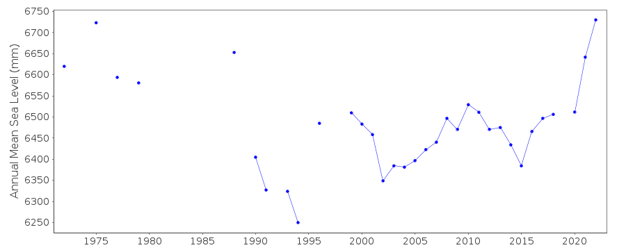 PSMSL Annual Mean Sea Level for '1333'  PSMSL Monthly Mean Sea Level for '1333' 
|
|
|