 |
SEALEVEL STATION CATALOG (SSC) |
|
|
|
|
|
| Station catalog metadata [edit] | [station overview] |
|---|
| SSC ID | SSC-bele | | Station Name | Belem | | Country | Brazil | | Latitude | -1.45 | | Longitude | -48.5 | | DateLastModified | 2015-10-22 19:02:29 |
| Distributed metadata source: IOC Sea Level Station Monitoring Facility bele |
|---|
| GTS station code | B5B01A70 |
| GTS message type | SEPO40 |
| Status | Operational |
| Local Contact | Instituto Brasileiro de Geografia e Estatística ( Brasil ) |
| Connection | GTS message |
| Country | Brasil |
| Sensor 1 | |
| Type of sensor | rad |
| Sampling rate (min) | 1 |
| Sensor 2 | |
| Type of sensor | enc |
| Sampling rate (min) | 1 |
| Sensor 3 | |
| Type of sensor | bat |
| Sampling rate (min) | 5 |
| Distributed metadata source: IOC Sea Level Station Monitoring Facility bele2 |
|---|
| Status | Operational |
| Local Contact | Instituto Brasileiro de Geografia e Estatística ( Brasil ) |
| Connection | WEB service |
| Country | Brasil |
| Sensor 1 | |
| Type of sensor | rad |
| Sampling rate (min) | 1 |
| Sensor 2 | |
| Type of sensor | enc |
| Sampling rate (min) | 1 |
| Distributed metadata source: UHSLC |
| UHSLC id | 229 |
| SSC id | bele |
| UHSLC geojson | https://uhslc.soest.hawaii.edu/data/meta.geojson |
| Research quality data version a | 1955-01-01 - 1968-12-31 |
| RQ basin | atlantic |
| Distributed metadata source: PSMSL |
| Name | BELEM |
| UHSLC ID | 229 |
| SONEL id | 2999 |
| Is RLR | Y |
| Has RLR Diagram | Y link |
| QC Flag | N |
| Old ID | 874/161 |
| Last Updated | null |
| Supplier | N.O.A.A. / N.O.S. |
| Address | N.O.A.A. / N.O.S., N/oes33, Ssmc4, Room 6531, 1305 East-West Highway, Silver Spring, , MD 20910, UNITED STATES |
| Metric Start | 1949 |
| Metric End | 1968 |
| Metric Completeness | 100.0 |
| RLR Start | 1949 |
| RLR End | 1968 |
| RLR Completeness | 100.0 |
| Download metric sea level data. | Use only with extreme caution. |
IOC Sea Level Station Monitoring Facility - realtime graph for 'bele'  IOC Sea Level Station Monitoring Facility - realtime graph for 'bele2'  PSMSL Annual Mean Sea Level for '580' 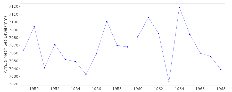 PSMSL Monthly Mean Sea Level for '580' 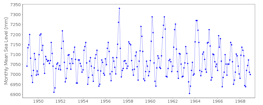
|
|
|