 |
SEALEVEL STATION CATALOG (SSC) |
|
|
|
|
|
| Station catalog metadata [edit] | [station overview] |
|---|
| SSC ID | SSC-auct | | Station Name | Auckland-Waitemata Hbr. | | Country | New Zealand | | Latitude | -36.8314 | | Longitude | 174.7865 | | DateLastModified | 2021-12-10 14:08:15 |
| Distributed metadata source: IOC Sea Level Station Monitoring Facility auct |
|---|
| GTS station code | AUCT |
| GTS message type | SZNZ01 |
| Status | Operational |
| Local Contact | Land Information New Zealand ( New Zealand ) |
| Connection | GTS message |
| Country | New Zealand |
| Sensor 1 | |
| Type of sensor | prs |
| Sampling rate (min) | 1 |
| Distributed metadata source: GLOSS Station Handbook |
|---|
| Time Zone | 180E, GMT + 12hrs | | Ocean | Pacific | | Operational | Yes | | Responsible country | New Zealand | | Tide gauge benchmarks | Auckland Harbour Board Benchmark (AHB BM), lead arrow on coping of sea wall near launch steps west of Ferry Buildings | | Benchmark relationships | Tide Gauge Zero (TGZ) = 5.005m below AHB BM
TGZ = 5.032m below BM CC 63
TGZ = 5.331m below BM CC 64
| | Auxiliary benchmarks | BM CC 63 Stainless steel pin near AHB BM
BM CC 64 Tide gauge room, shed 17, Queens Wharf (No longer exists 1992).
| | Other relevant information | Auckland Harbour Board are presently trialing a new tide gauge. The position and details will be supplied when operational. Both old and new gauges are maintained. A Munro clock/float gauge will be retained for the foreseeable future. The new gauge is a New Zealand made DSIR system, using a pressure transducer and data logger, with UHF telemetry to the Port Company Offices. | | Other relevant codes | UHSLC 070 |
| Distributed metadata source: PTWC COMP META file |
| DCP ID | AUCT |
| WMO | SZNZ01 |
| Samp Rate | 1 |
| Num# Samp | 6 |
| Unit | M |
| Scale | 1.0000 |
| Xmt Int. | 003 |
| Fst Min. | 0000 |
| HAR | 1 |
| Owner | GNS |
| Distributed metadata source: UHSLC |
| UHSLC id | 070 |
| SSC id | auct |
| GLOSS id | 127 |
| UHSLC geojson | https://uhslc.soest.hawaii.edu/data/meta.geojson |
| Research quality data version a | 1984-05-01 - 1988-12-31 |
| RQ basin | pacific |
| Distributed metadata source: PSMSL |
| Name | AUCKLAND II |
| GLOSS id | 127 |
| UHSLC ID | 70 |
| SONEL id | 2545 |
| Is RLR | Y |
| Has RLR Diagram | Y link |
| QC Flag | N |
| Old ID | 690/002 |
| Last Updated | 2003-06-09 |
| Supplier | DEPT. OF SURVEY AND LAND, N.Z. |
| Address | Department of Survey and Land Information, P.O. Box 170, Wellington, NEW ZEALAND |
| Metric Start | 1903 |
| Metric End | 2000 |
| Metric Completeness | 95.8 |
| RLR Start | 1903 |
| RLR End | 2000 |
| RLR Completeness | 95.8 |
| Download metric sea level data. | Use only with extreme caution. |
| Name | AUCKLAND-WAITEMATA HARBOUR |
| GLOSS id | 127 |
| UHSLC ID | 70 |
| SONEL id | 2545 |
| Is RLR | Y |
| Has RLR Diagram | Y link |
| QC Flag | N |
| Old ID | 690/001 |
| Last Updated | 1999-08-27 |
| Supplier | DEPT. OF SURVEY AND LAND, N.Z. |
| Address | Department of Survey and Land Information, P.O. Box 170, Wellington, NEW ZEALAND |
| Metric Start | 1917 |
| Metric End | 1998 |
| Metric Completeness | 26.9 |
| RLR Start | 1917 |
| RLR End | 1998 |
| RLR Completeness | 26.9 |
| Download metric sea level data. | Use only with extreme caution. |
IOC Sea Level Station Monitoring Facility - realtime graph for 'auct' 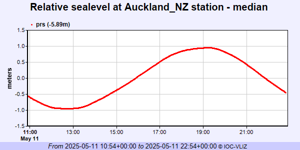 PSMSL Annual Mean Sea Level for '150' 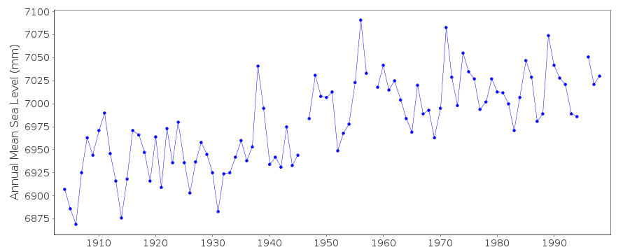 PSMSL Annual Mean Sea Level for '217' 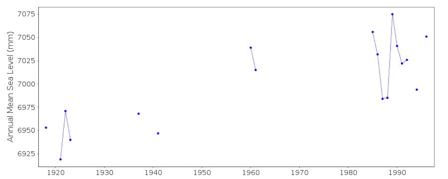 PSMSL Monthly Mean Sea Level for '217' 
|
|
|