 |
SEALEVEL STATION CATALOG (SSC) |
|
|
|
|
|
| Station catalog metadata [edit] | [station overview] |
|---|
| SSC ID | SSC-ande | | Station Name | Andenes | | Country | Norway | | Latitude | 69.316667 | | Longitude | 16.15 | | DateLastModified | 2015-10-22 19:02:29 |
| Distributed metadata source: IOC Sea Level Station Monitoring Facility ande |
|---|
| Status | Operational |
| Local Contact | Norwegian Hydrographic Service ( Norway ) |
| Connection | WEB service |
| Country | Norway |
| Sensor 1 | |
| Type of sensor | flt |
| Sampling rate (min) | 10 |
| Distributed metadata source: GLOSS Station Handbook |
|---|
| Time Zone | 015E, GMT + 1hr | | Operational | Yes | | Responsible country | Norway | | Data acquisition rate | 10 minute interval | | Tide gauge benchmarks | TGBM: L7 N42 | | Benchmark relationships | Auxiliary BM: L7 N33: 1.354 m below TGBM
Auxiliary BM: L7 N34: 1.782 m below TGBM
Normalnull 1954: 3.245 m below TGBM
TGZ: 5.245 m below TGBM | | Other relevant information | GPS antenna on gauge |
| Distributed metadata source: UHSLC |
| UHSLC id | 800 |
| SSC id | ande |
| GLOSS id | 322 |
| UHSLC geojson | https://uhslc.soest.hawaii.edu/data/meta.geojson |
| Research quality data version a | 1991-10-09 - 2018-12-31 |
| RQ basin | atlantic |
| Fast delivery | 1991-10-09 - 2026-05-31 |
| Distributed metadata source: PSMSL |
| Name | ANDENES |
| GLOSS id | 322 |
| UHSLC ID | 800 |
| SONEL id | 3573 |
| Is RLR | Y |
| Has RLR Diagram | Y link |
| QC Flag | N |
| Old ID | 040/041 |
| Last Updated | 2026-01-30 |
| Supplier | NORWEGIAN MAPPING AUTHORITY |
| Address | Norwegian Mapping Authority, Hydrographic Service , Po. Box 60, 4001 Stavanger, NORWAY |
| Metric Start | 1938 |
| Metric End | 2025 |
| Metric Completeness | 67.2 |
| RLR Start | 1938 |
| RLR End | 2025 |
| RLR Completeness | 67.2 |
| Download metric sea level data. | Use only with extreme caution. |
IOC Sea Level Station Monitoring Facility - realtime graph for 'ande' 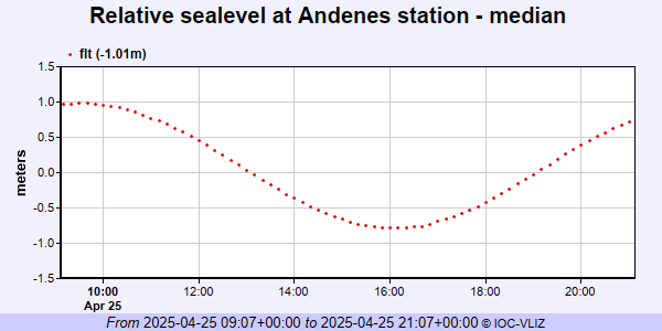 PSMSL Annual Mean Sea Level for '425' 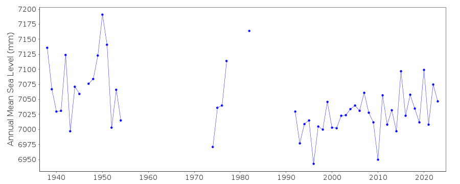 PSMSL Monthly Mean Sea Level for '425' 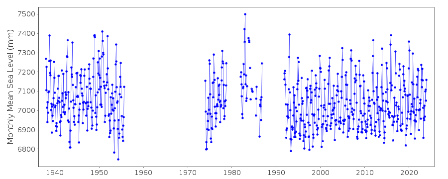
|
|
|