 |
SEALEVEL STATION CATALOG (SSC) |
|
|
|
|
|
| Station catalog metadata [edit] | [station overview] |
|---|
| SSC ID | SSC-acnj | | Station Name | Atlantic City | | Country | United States | | Latitude | 39.355 | | Longitude | -74.4183 | | DateLastModified | 2015-10-22 19:02:29 |
| Distributed metadata source: IOC Sea Level Station Monitoring Facility acnj |
|---|
| GTS station code | 3367B730 |
| GTS message type | SXXX03 |
| Status | Operational |
| Local Contact | National Ocean Service-NOAA ( USA ) |
| Connection | WEB service |
| Country | USA |
| Sensor 1 | |
| Type of sensor | wls |
| Sampling rate (min) | 1 |
| Distributed metadata source: IOC Sea Level Station Monitoring Facility acnj2 |
|---|
| GTS station code | 3367B730 |
| GTS message type | SXXX03 |
| Status | Operational |
| Local Contact | National Ocean Service-NOAA ( USA ) |
| Connection | GTS message |
| Country | USA |
| Sensor 1 | |
| Type of sensor | pwl |
| Sampling rate (min) | 1 |
| Distributed metadata source: GLOSS Station Handbook |
|---|
| Time Zone | 075W, GMT - 5hrs | | Ocean | Atlantic | | Operational | Yes | | Auxiliary benchmarks | ETG RM (50.000ft)
4720 H 1993 (26.056ft)
4720 B 1979 (25.077ft)
4720 I 1993 (32.046ft)
4720 C 1980 (23.408ft)
Tidal 31 Reset (24.807ft)
Heights are above tide staff zero
No 1 stamping (27.185ft)
30 1922 (26.188ft)
| | Other relevant information | Tide hut is 6x6ft orange fibre glass shelter located on the offshore end of the Taj Mahal Pier.
Leupold and Stevens gauge is mounted on top of laminated counter top in NE corner of the gauge house.
| | Other relevant codes | UHSLC 264 |
| Distributed metadata source: PTWC COMP META file |
| DCP ID | 3367B730 |
| WMO | SXXX03 |
| Samp Rate | 6 |
| Num# Samp | 1 |
| Unit | M |
| Scale | 1.3534 |
| Xmt Int. | 006 |
| Fst Min. | 0005 |
| HAR | 1 |
| Owner | NOS |
| Distributed metadata source: UHSLC |
| UHSLC id | 264 |
| SSC id | atla |
| GLOSS id | 220 |
| UHSLC geojson | https://uhslc.soest.hawaii.edu/data/meta.geojson |
| Research quality data version a | 1911-08-19 - 2021-12-31 |
| RQ basin | atlantic |
| Fast delivery | 1911-08-19 - 2026-05-31 |
| Distributed metadata source: PSMSL |
| Name | ATLANTIC CITY |
| GLOSS id | 220 |
| UHSLC ID | 264 |
| SONEL id | 2923 |
| Is RLR | Y |
| Has RLR Diagram | Y link |
| QC Flag | N |
| Old ID | 960/091 |
| Last Updated | 2026-01-27 |
| Supplier | N.O.A.A. / N.O.S. |
| Address | N.O.A.A. / N.O.S., N/oes33, Ssmc4, Room 6531, 1305 East-West Highway, Silver Spring, , MD 20910, UNITED STATES |
| Metric Start | 1911 |
| Metric End | 2025 |
| Metric Completeness | 93.1 |
| RLR Start | 1911 |
| RLR End | 2025 |
| RLR Completeness | 93.1 |
| Download metric sea level data. | Use only with extreme caution. |
IOC Sea Level Station Monitoring Facility - realtime graph for 'acnj' 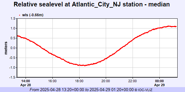 IOC Sea Level Station Monitoring Facility - realtime graph for 'acnj2' 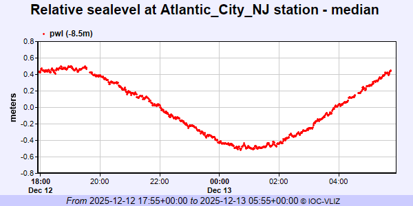 PSMSL Annual Mean Sea Level for '180' 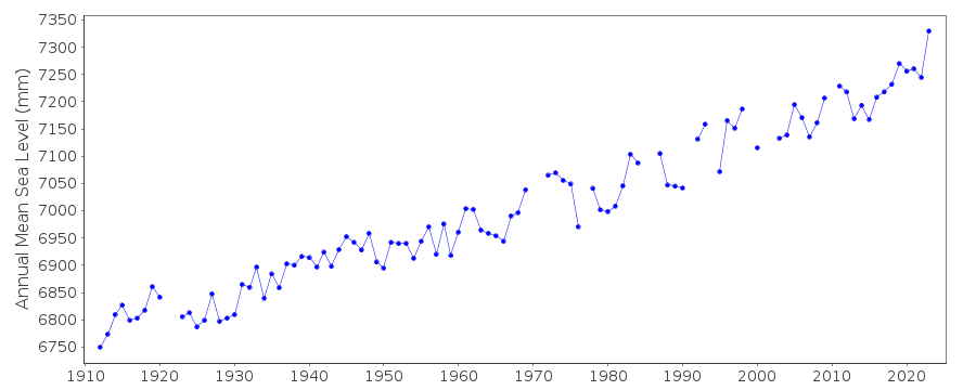 PSMSL Monthly Mean Sea Level for '180' 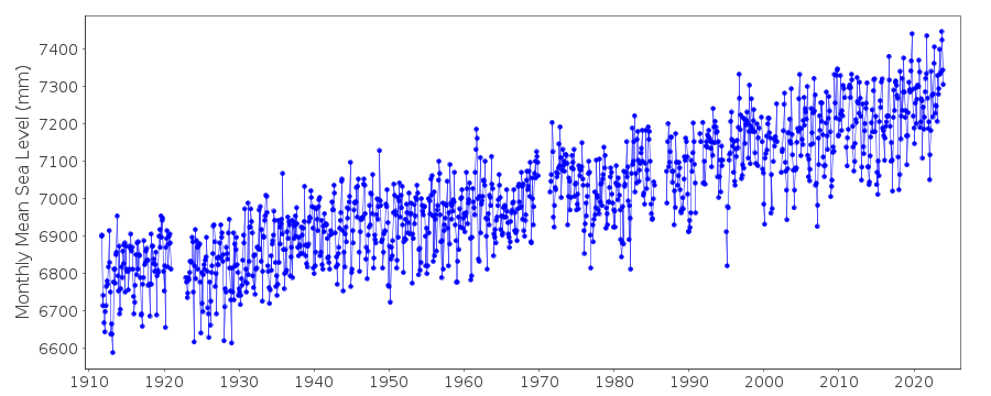
|
|
|