 |
SEALEVEL STATION CATALOG (SSC) |
|
|
|
|
|
| Station catalog metadata [edit] | [station overview] |
|---|
| SSC ID | SSC-aburr | | Station Name | Aburatsubo | | Country | Japan | | Latitude | 35.160278 | | Longitude | 139.615278 | | DateLastModified | 2015-10-22 19:02:29 |
| Linked codes |
|---|
| Codes | Location | Latitude | Longitude | Sensors | PSMSL: 130 | ABURATSUBO | 35.160278 | 139.615278 | N/A |
SONEL_GPS: 779 | ABURATSUBO | 35.16015278 | 139.61553330 | N/A |
SONEL_TG: 2210 | ABURATSUBO | 35.16019900 | 139.61535000 | N/A |
| Distributed metadata source: PSMSL |
| Name | ABURATSUBO |
| SONEL id | 779 |
| Is RLR | Y |
| Has RLR Diagram | Y link |
| QC Flag | N |
| Old ID | 642/091 |
| Last Updated | 2026-04-01 |
| Supplier | GEOGRAPHICAL SURVEY INSTITUTE |
| Address | Geographical Survey Institute, Kitasato -1, Tsukuba-shi, Ibaraki-ken 305, JAPAN |
| Metric Start | 1900 |
| Metric End | 2025 |
| Metric Completeness | 98.1 |
| RLR Start | 1930 |
| RLR End | 2025 |
| RLR Completeness | 97.7 |
| Download metric sea level data. | Use only with extreme caution. |
PSMSL Annual Mean Sea Level for '130' 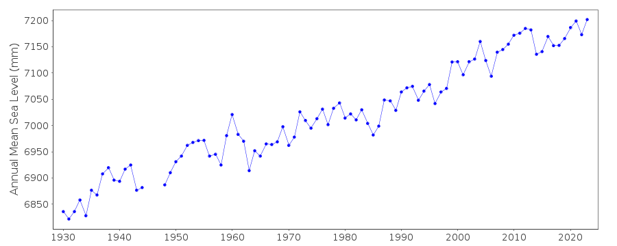 PSMSL Monthly Mean Sea Level for '130' 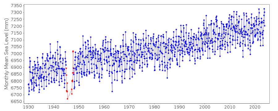
|
|
|