 |
SEALEVEL STATION CATALOG (SSC) |
|
|
|
|
|
| Station catalog metadata [edit] | [station overview] |
|---|
| SSC ID | SSC-abas | | Station Name | Abashiri | | Country | Japan | | Latitude | 44.01666 | | Longitude | 144.28333 | | DateLastModified | 2015-10-22 19:02:29 |
| Distributed metadata source: IOC Sea Level Station Monitoring Facility abas |
|---|
| GTS station code | ABASHIRI |
| GTS message type | SWJP40 |
| Status | Operational |
| Local Contact | Japan Meteorological Agency ( Japan ) |
| Connection | GTS message |
| Country | Japan |
| Sensor 1 | |
| Type of sensor | rad |
| Sampling rate (min) | 1 |
| Distributed metadata source: GLOSS Station Handbook |
|---|
| Operational | Yes | | Responsible country | Japan | | Benchmark relationships | All data are referred to a Datum Line (DL) associated with the tide gauge.
The Standard Mark (SM) is physically located near the tide gauge and is directly levelled to a First Order Bench Mark of the Geographical Survey Institute.
The SM is 4.407m above the DL and 3.044m above the TP (mean sea level of Tokyo Bay, or Peil). | | Other relevant codes | UHSLC 347A |
| Distributed metadata source: PTWC COMP META file |
| DCP ID | ABAS |
| WMO | SWJP40 |
| Samp Rate | 1 |
| Num# Samp | 10 |
| Unit | F |
| Scale | 1.0000 |
| Xmt Int. | 010 |
| Fst Min. | 0009 |
| HAR | 1 |
| Owner | JMA |
| Distributed metadata source: UHSLC |
| UHSLC id | 347 |
| SSC id | abas |
| GLOSS id | 327 |
| UHSLC geojson | https://uhslc.soest.hawaii.edu/data/meta.geojson |
| Research quality data version a | 1955-12-06 - 2023-12-31 |
| RQ basin | pacific |
| Fast delivery | 1955-12-06 - 2026-05-31 |
| Distributed metadata source: PSMSL |
| Name | ABASHIRI |
| GLOSS id | 327 |
| UHSLC ID | 347 |
| SONEL id | 797 |
| Is RLR | Y |
| Has RLR Diagram | Y link |
| QC Flag | N |
| Old ID | 641/003 |
| Last Updated | 2026-04-07 |
| Supplier | JAPAN METEOROLOGICAL AGENCY |
| Address | Japan Meteorological Agency, 3-6-9 Toranomon, Minato City, Tokyo, JAPAN |
| Metric Start | 1965 |
| Metric End | 2025 |
| Metric Completeness | 96.6 |
| RLR Start | 1965 |
| RLR End | 2025 |
| RLR Completeness | 96.6 |
| Download metric sea level data. | Use only with extreme caution. |
IOC Sea Level Station Monitoring Facility - realtime graph for 'abas' 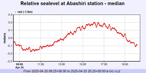 PSMSL Annual Mean Sea Level for '1104'  PSMSL Monthly Mean Sea Level for '1104' 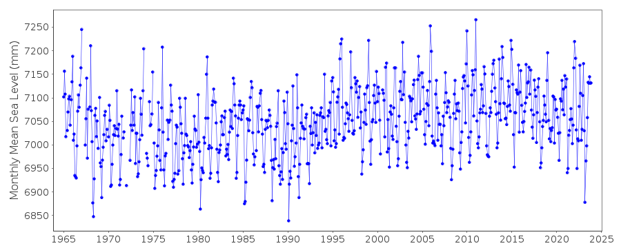
|
|
|